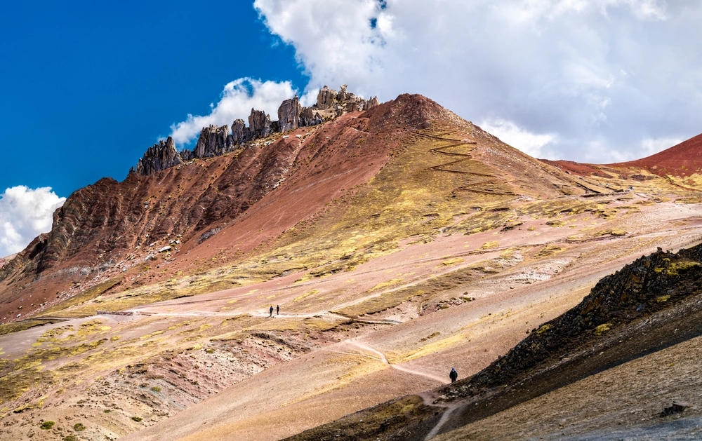
It’s a valley where the color red dominates the landscape in a range of earthy and ochre tones that cover the rolling hills. This natural effect is due to the presence of minerals like iron, which have tinted the soil over time.
The environment is open and arid, with sparse vegetation. You’ll only find Ichu (Andean grass) growing on the dry ground of the Andes. There are no trees or shade—just wind, silence, and the vastness of the landscape.
The route is made up of moderate slopes and dirt trails. Along the way, it’s common to see llamas or alpacas, and from the viewpoints, the panoramic view reveals an impressive reddish mountain.
Also known as "Puka Pampa" in Quechua, it’s more than just a landscape—it was part of ancient Inca pilgrimage routes toward Ausangate, a sacred mountain deeply revered by Andean communities. Local myths speak of a hidden fire beneath the earth, a protective force that safeguarded the valley and its inhabitants.
Stories are told of spiritual guardians who dwell in the mountains, offering their protection only to those who honor nature and keep their traditions alive.
According to an ancient Andean legend, countless generations ago, two powerful Apus (mountain spirits) clashed in a fierce battle for control of the territory. The intensity of their fight left the land scarred with oxidized rock, and the divine blood of the gods flowed through the ravines, painting the hills a fiery red. Since then, it’s believed that each sunrise in the Red Valley echoes that ancestral battle, reflected in the vibrant scarlet tones that cover its soil.
The Red Valley is located in the province of Canchis, district of Pitumarca, in the Cusco region, at over 5,000 meters above sea level. It forms part of the majestic Ausangate mountain range and is very close to Vinicunca.
Early in the morning, take public transportation to Pitumarca, which takes approximately 3 hours. From there, you’ll need to get a shared ride, local taxi, or private transport to the community of Japura or K’ayrawiri—this is the starting point of the hike.
Remember that Cuscoperu.com helps you have the best experience on this journey. We organize all transportation, logistics, and support so that all you have to do is enjoy the scenery and the adventure. Also, keep in mind that we have professional guides who are fully committed to your experience.
The Red Valley is located at approximately 5,000 meters above sea level. Therefore, it’s recommended to spend 2 days in the city of Cusco or at a lower altitude before starting the hike.
The Red Valley doesn’t have a strict entry schedule, but it’s recommended to visit between approximately 6:00 a.m. and 3:00 p.m. so you can make the most of the daylight, favorable weather, and—most importantly—stay safe along the route.
Get ready for an adventure that will take you through a landscape that feels like another world. In the Red Valley, the mountains tell stories in reddish tones, and each step brings you closer to a moment that will stay with you forever.

Qelccaya, unlike polar glaciers, is located in the tropical belt of the Peruvian Andes, making it a key natural laboratory for the study of climate change. It has also been studied by NASA and international universities.
Quelccaya is an ice cap with an approximate altitude between 5,200 and 5,700 meters above sea level. It is important for humanity because its ice layers preserve information about atmospheric and climate changes over time. Its progressive disappearance makes its protection urgent because, thanks to its ice mass, it acts as an important freshwater reserve, vital for human consumption and agriculture.
It is located in the Vilcanota mountain range, one of the most important mountain chains in the Peruvian Andes. It is in southern Peru, within the department of Cusco, specifically in the province of Canchis and the district of Pitumarca.
You can reach Qelccaya on your own by taking transportation to the town of Phinaya, located approximately 4 to 5 hours away by road. From Phinaya, the route involves a demanding 2 to 4-hour hike to reach the glacier’s edge, depending on the visitor’s pace and acclimatization.
Please note that there is no official tourist signage to reach Quelccaya, so it is essential to visit with a specialized guide. At CuscoPeru.com, we have the necessary experience to help you enjoy this adventure safely and memorably. Contact us so our travel advisors can help you plan your trip.
The name Qelqaya comes from the Quechua language: “qillqay” or “qelqay,” meaning “writing” or “to write,” and “-ya,” which indicates a place.
Therefore, Qelqaya can be interpreted as “the place where writing happens” or “the one that writes.” This name reflects the idea that it is a climate manuscript, whose ice layers act like pages preserving the region’s climate history over the centuries.
The stories and legends surrounding the Quelccaya glacier reflect the rich cultural tradition of Andean communities. Shamans from the community of Huito say that, when night falls, Quelccaya makes sounds similar to thunder, which do not come from the sky but from inside the glacier. It is said that these noises are laments, a sign that people have lost respect for it.
Another local legend tells that, centuries ago, Quelccaya was a wise being who wrote the secrets of the world in ice. The gods, seeing that humans did not know how to read them, decided to make it slowly disappear, so only those who truly listen to nature would understand its message.
The Quelccaya glacier has been retreating rapidly in recent decades, showing the real impact of climate change. This phenomenon shows that global warming is altering our environment and warns of the urgent need to act to reduce its effects.
By losing much of its ice, Quelccaya not only changes the Andean landscape but also affects the ecosystems and communities that depend on its waters. The reduction in the flow of rivers that emerge from this glacier is limiting access to water, creating great concern among local residents.
The most suitable season to visit Quelccaya is during the dry months, from May to September, when conditions are more favorable for hiking.
We recommend leaving early in the morning to take advantage of the soft light and enjoy the landscape with fewer visitors. This will also allow you to have a quieter experience in contact with nature.
Quelccaya is more than ice: it is part of nature that becomes more fragile every day because of climate change. Cuscoperu.com invites you to discover this place full of history.
Near the historic center of Cusco, there is a place that seems straight out of a magical tale. Surrounded by ancient terraces, vegetation, Inca canals, and a small but charming waterfall, Sapantiana is the perfect place that showcases colonial heritage and Andean spirit. It is a space where visitors immerse themselves in a unique experience that combines history, mysticism, and nature in perfect harmony.
The Colonial Aqueduct of Sapantiana represents a remarkable example of hydraulic engineering from the viceregal era, built over the P’ujru River. Its construction, dating back to the 17th and 18th centuries, was promoted by the Jesuit order along with the Cusco council. This stone structure, composed of arches distributed over four levels, likely reused lithic materials from the nearby Sapantiana huaca. Until before 1950, the channel at the top still carried water for the supply of the viceregal city. Today, it remains a living testament to history, standing firm against the wear of time.
The name "Sapantiana" highlights the spiritual dimension of the place, referring to a sacred space reserved for the veneration of an Inca huaca. The word comes from Quechua, combining “Tiana” (seat) and “Sapan” (unique), which translates to “The place where the huaca sits alone.”
Sapantiana holds a deep history that links the Inca legacy with the colonial era. This structure was part of an ancient network of roads and canals that integrated various agricultural sectors of Cusco. The channel flowing under the bridge belongs to an Inca hydraulic system still in operation, which once supplied terraces, fountains, and cultivation areas. This space has high cultural value, representing the fusion of two construction traditions: the ancestral engineering of the Incas and the architecture brought by the colonizers.
It is located in the San Blas neighborhood, one of the most traditional areas of Cusco, about 15 minutes on foot from the Plaza de Armas. It is situated in a ravine known for its ancient cobbled paths and surrounded by a natural environment that remains almost intact despite its proximity to the city.
Upon arrival, visitors can observe a single-arch stone bridge, covered with moss and wild plants. Beneath it runs a channel of crystal-clear water, and nearby falls a small waterfall, surrounded by ferns and stone walls. The surroundings include:
The sound of water and birdsong make this place a small oasis of peace within the city.
Recommended walking option:
Getting to Sapantiana is quite easy. From Cusco’s central square, head to Triunfo Street, which is to the left of the grand cathedral. Then, walk straight to Hatun Rumiyoc, a narrow pedestrian street where you can see the twelve-angled stone in the Inca wall. Next, enter Choquechaca Street and follow it to the end. Finally, climb the stairs and follow the small stream, as it passes under the colonial arch.
Useful tip: You can also take a taxi to the upper parts of San Blas and then take a short walk.
Best time to go: Dry season (April to October), when the paths are firmer and the weather is stable.
What to bring:
Avoid going at night: There is no lighting on the trail.
Traveler Testimonials
Discover Sapantiana, Cusco’s best-kept secret, and let yourself be carried away by the sound of water, the history in stone, and the magic that only authentic corners can offer.
The Abode of the Gods, known as Apukunaq Tianan, is an artistic site featuring sculptures carved into rock, located in the Sencca sector, in the district of Poroy, near the city of Cusco. The site is surrounded by mountains and nature, where you can discover, through sculpture, part of Cusco’s history.
An ideal place for travelers who love art, history, and Andean landscapes. The Abode of the Gods allows you to enjoy hiking, cycling, meditation, or simply contemplating the spiritual surroundings, because more than just a tourist attraction, it is an invitation to reconnect with the ancient essence of the Andes.
"Apukunaq Tianan" comes from Quechua and is interpreted in Spanish as “guardian gods of the mountains.”
According to Andean beliefs, the Apus are spiritual protectors who dwell in the mountains. For this reason, Apukunaq Tianan was designed to honor the first peoples of Peru and their spiritual legacy.
Today, the site is presented as a space inspired by Andean spirituality and the ancestral stories of the region. According to some of the stories shared at the site, the Apus appeared to the local people through dreams or visions, offering them guidance. Others claim that this was a center of spiritual connection, where wise men or paqos (known as healers) came to meditate and communicate with the gods.
Michael Monteagudo, the sculptor and creator of the magnificent artworks that make up Apukunaq Tianan, was born on August 17, 1983, in the picturesque town of Ichiquiato, in the district of Echarate, province of La Convención, Cusco.
During his childhood, he discovered his natural talent for sculpture, inspired by the wise advice of his grandmother, Doña Juana, who taught him the values needed to become a man proud of his roots and of the ancestral culture of the Incas. He began his artistic journey with small creations, quickly standing out thanks to his discipline and determination.
The creator of the monuments that decorate the Abode of the Gods was inspired by his way of seeing the world of Andean cultures, blending myths, spirituality, and traditions of pre-Hispanic peoples, with a special focus on everything related to Inca culture.
Most of the sculptures were handmade, without heavy machinery, using chisels, hammers, and traditional tools, which gives his work even greater value.
Among the best-known sculptures at the site are:
This sculpture of Mother Earth seems to emerge from the depths of the mountain, representing the respect and spiritual bond that Andean peoples maintain with the earth.
Considered the second largest feline in the Americas after the jaguar, it was one of the most sacred animals for the Incas. Its strength, agility, and wisdom made it a symbol of power that remains present to this day. That is why its presence in Apukunaq Tianan represents energy and protection, accompanying you throughout your visit.
One of the most powerful and revered deities of the Inca Empire, he is the supreme creator of all things. In the Andean worldview, Wiracocha emerges from chaos to shape the world. His image is displayed majestically, carved into living rock, holding a citadel in his hand, a symbolic representation of his creative power.
This sculpture symbolizes the ancient “Children of the Sun,” protagonists of Inca history. According to Andean tradition, it was the Sun god who sent Manco Cápac and Mama Ocllo to found one of the greatest empires in South America. As you look at this figure, you will feel the strength of a civilization that left an unforgettable mark on history.
The Amazon formed part of the eastern horizon of the Inca world, linked to Antisuyo, and it was always seen as a mysterious and fascinating place. At the Abode of the Gods, this sculpture pays tribute to the Amazonian peoples and the cultural richness of the tropical forest.
It represents the three planes of existence: Hanan Pacha (the upper world), Kay Pacha (the earthly world), and Uku Pacha (the inner world). Crossing this door is a symbolic act of introspection and transcendence.
Within the Andean worldview, symbolic doors were considered portals that allowed priests to move between different sacred spaces. Although this impressive sculpture does not possess that mystical quality, it will undoubtedly awaken your imagination. At the top stands the image of the Sun god, while at the center appears the face of an Inca crowned with three coca leaves, a symbol of wisdom and spiritual connection.
This is the perfect spot to admire the rural landscape of the Sencca sector and breathe fresh air. From here, you can enjoy open views and capture memorable photographs that will make your visit an unforgettable experience.
The Abode of the Gods is located in the community of Sencca, in the district of Poroy, just a few kilometers from downtown Cusco. At an approximate altitude of 3,850 meters above sea level (12,700 ft), it is surrounded by mountains, farmland, and stunning Andean scenery.
From downtown Cusco, there are three ways to get there:
The main access is via an unpaved road that leads directly to the site. It is also very common to arrive by bicycle or hiking, as there are adventure routes crossing rural Andean landscapes. The path is suitable for all types of visitors, although there are some sloped areas, so wearing comfortable shoes is recommended.
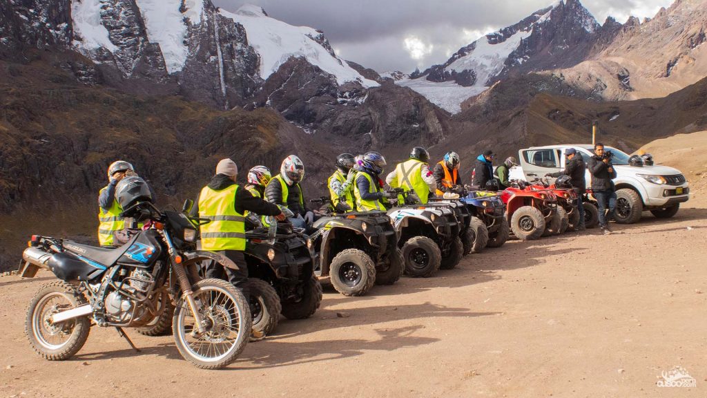
At CuscoPeru.com, we help you plan your visit to the Abode of the Gods, where we offer a tour that includes an ATV ride so you can make the most of your adventure. Our travel agents make sure you enjoy a pleasant and safe trip without any setbacks.
Opening hours: Monday to Sunday from 8:30 a.m. to 5:30 p.m.
General admission: Entrance for Peruvian adult visitors is 15 soles, and for foreign adult visitors, 20 soles.
Important: Opening hours and fees may vary, so we recommend confirming them before your visit.
We recommend visiting the Abode of the Gods during the dry season, which runs from April to October, since the weather is more stable and the roads are in better condition.
It is important to bring:
Altitude: Since it is located at nearly 4,000 meters above sea level, it is important to acclimatize beforehand if you are coming from lower-altitude areas. You should avoid sudden physical effort and remember to stay hydrated.
This mountain is one of Cusco’s newest tourist attractions. It gained popularity during the 2020 lockdown, becoming famous for its colorful tones. Its colors and shapes resemble Andean ponchos.
Beyond its striking colors, Pallay Punchu is home to a medicinal plant called Sasawi, which has been used for generations in the area to treat respiratory illnesses.
It is an alternative to other colorful mountains in Cusco, especially for those looking for less crowded routes. With colors ranging from pinks, purples, and ochres to greens and whites, its tones are due to the presence and oxidation of different minerals in the rock. They also resemble traditional Andean ponchos.
Pallay Punchu is located in the Cusco region, in the district of Layo, province of Canas. It has an approximate altitude of 4,791 meters above sea level at its highest point and is more than 190 kilometers from the city of Cusco. The weather is cold and windy, typical of high mountain areas, so proper acclimatization is recommended before starting the hike.

There are two main routes to reach Pallay Punchu:

The route, which varies between 8 and 10 kilometers, allows you to enjoy almost unexplored landscapes and panoramic views. Some attractions you will see are the following:
It is located at an approximate altitude of 4,791 meters above sea level and has cold, variable weather. The mornings are freezing, followed by sunny midday hours, but with strong winds. The hiking difficulty is moderate to high due to the altitude and steep slopes; therefore, good physical condition is required.
The best time to visit Pallay Punchu is between April and October, when the weather is dry and sunny.
The rainy season presents a greater challenge and does not guarantee that you will be able to enjoy the views.
Dry season: During these months, the days are sunny, with pleasant temperatures ranging between 5 °C and 18 °C. The sky remains clear most of the time, and at night the temperature usually drops to 0 °C.
Rainy season: Rainfall is frequent, especially in the afternoons and evenings. Rain can be heavy, making access to some areas difficult. Temperatures are milder than in the dry season, averaging 15 °C. Fog is also common, especially in the mornings; this can affect visibility, make hiking more difficult, and limit panoramic views.
It is recommended for people who enjoy hiking and have good physical condition for a high-altitude route.
Unlike its famous neighbor Vinicunca, Palcoyo offers a peaceful and less demanding experience, ideal for those who want to explore the Andes without the crowds. In this article, we tell you everything you need to know to discover this surprising destination near Cusco.
It is a little-known treasure in the Cusco region, a less demanding and less crowded alternative to the famous Rainbow Mountain, Vinicunca, but with comparable beauty. Its multicolored mountains are the result of the oxidation of minerals such as iron and clay, with vibrant shades of red, green, yellow, and purple, creating a landscape that looks like a painting. In addition to its impressive coloring, Palcoyo has a mysterious stone forest, a unique geological formation that adds a magical touch to the route. From its natural viewpoints, you can enjoy impressive panoramic views of the imposing Ausangate snow-capped mountain. It is ideal for those looking for an experience similar to the Rainbow Mountain Tour, but with less effort and more tranquility.
Palcoyo is located in the Cusco region, in the district of Checacupe, province of Canchis. At an approximate altitude of 4,900 meters above sea level, it is located about 100 to 125 km south of the city of Cusco.
The weather varies depending on the season, usually with cold mornings and sunny afternoons. Temperatures can range approximately between 5 °C and 18 °C during the day, with very cold mornings and nights, so it is important to be prepared for sudden weather changes. Since this is a high mountain area, proper acclimatization is recommended before the visit to avoid possible adverse effects of altitude.
The drive takes approximately 3 hours, passing through picturesque towns such as Checacupe before reaching the starting point of the hike.
Unlike Vinicunca, the hike in Palcoyo is short and accessible, with a 45-minute route along trails without steep slopes.
To get to Palcoyo from Cusco, the best option is to book a tour with a local travel agency. You can see our offer here: Palcoyo Rainbow Mountain Tour.

It is very similar to Rainbow Mountain, but it is a more accessible option in terms of hiking, as reaching the top takes only 45 minutes and does not require great physical effort. Palcoyo has three mountains with different colors due to the presence of various minerals, with iron oxides and clays ranging between reddish, greenish, and yellow tones.
It is located about a 20-minute walk away, depending on the visitor’s pace. The stone forest is a group of rock formations that look like stone trees, like natural sculptures created by time and erosion.
During the dry season, you can enjoy panoramic views of the Ausangate snow-capped mountain and the valleys surrounding the area.
Rainbow Mountain has a moderate to high level of difficulty, with an approximate two-hour hike, while Palcoyo is more accessible and has no steep slopes.
Rainbow Mountain: it can receive a much larger flow of visitors, especially during high season.
Palcoyo: it usually receives fewer visitors than Vinicunca.
The hike to Palcoyo Mountain takes around 45 minutes.
It is located at an altitude of 4,900 meters above sea level. Therefore, it is necessary to acclimate at least one or two days before visiting the mountain, stay well hydrated, avoid fatty foods, and avoid pushing your body too hard.
No, it is not. The hike to the mountain is not demanding, and you can walk at your own pace. We recommend visiting during the dry season.
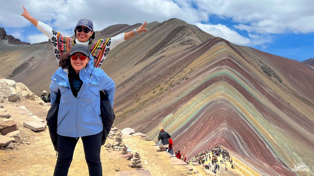
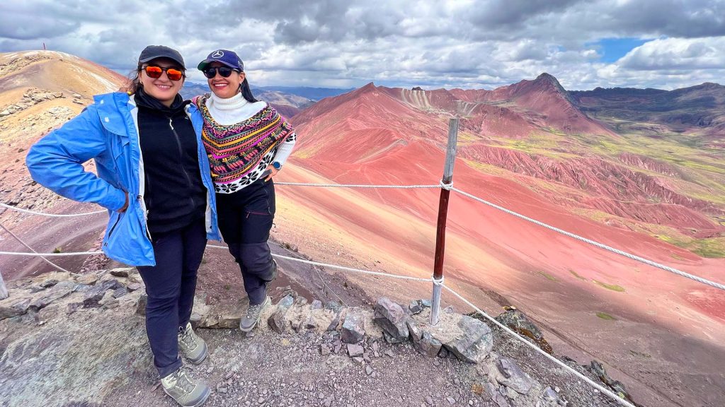
Rainbow Mountain, also known as Vinicunca, has become one of Cusco’s main tourist attractions. Its unique appearance, formed by mineral layers that create different tones, attracts thousands of national and international visitors every year. In this complete guide, you will find everything you need to know to plan your visit: how to get there, available routes, weather, recommendations, types of tours, prices, hiking difficulty, and key tips to make the most of your trip.
Located in the district of Pitumarca, in the Cusco region, Rainbow Mountain reaches an approximate altitude of 5,200 meters above sea level.
This high altitude contributes to the extreme weather conditions and landscapes that characterize this area. However, it is important to consider the risks of altitude sickness when visiting this natural attraction.
Its history dates back millions of years, when the area was covered by water. Sediments from seas, lakes, and rivers accumulated in layers, creating a palette of colors. Over time, tectonic movements lifted these layers, forming the mountain we know today.
For many years, the mountain was covered with snow. As a result of climate change, the colors that characterize it today were revealed, drawing the attention of locals and travelers.
Today, Vinicunca is one of the most visited tourist destinations thanks to its natural colorful tones and views of the Andes mountain range.
It receives this name because of the colorful stripes that characterize it. Its tones range from red and yellow to other shades, creating a striking, colorful landscape similar to a rainbow.
These colors are the result of different layers of sediment deposited in this area. These layers contained different minerals that, through oxidation and uneven erosion, created the variety of colors we see today.
Vinicunca, also known as Rainbow Mountain, comes etymologically from the Quechua term Winicunca, which means “narrow neck.”
Local residents also know it as Colored Mountain or Apu Winicunca.
The Apus are considered protective spirits in the Andean worldview and hold great importance for the communities living near Rainbow Mountain. The Apus are more than simple mountains: they are considered guardians that care for and protect people and the nature around them.
Rainbow Mountain is considered an Apu, and to show gratitude and respect, local residents perform offerings to Mother Earth to ask for protection and blessings.
According to studies, the mineralogical composition of Rainbow Mountain is as follows:
To get to Vinicunca, you will take a route that combines a drive and a hike. There are two main routes to reach the mountain: one through Pitumarca and the other through Cusipata. Both routes offer incredible panoramic views of the Andes mountain range.
The distance from Cusco to Pitumarca is approximately 3 hours. Upon arrival, you will continue to the base where the vehicle route ends. From there, you will begin your hike toward the fascinating Rainbow Mountain. If you prefer, you can rent a horse at the beginning or along the way up. This is the shortest and most direct route.
The distance from Cusco to Cusipata is approximately 2 hours. Upon arrival, you will continue by vehicle to the base of the mountain, where the road for cars ends. From there, you will begin your hike to Rainbow Mountain, or you can choose other options to go up, such as by motorcycle or horse. If you enjoy hiking, we recommend this route.
The weather in Vinicunca is strongly influenced by its altitude and location in the Andes. Weather conditions can vary throughout the year. In the Cusco region, there are two well-defined seasons: the dry season and the rainy season.
The rainy season in Vinicunca runs from November to April. During these months, the landscapes take on greener tones due to the rainfall. When visiting Rainbow Mountain, you may see snowy mountain views. Also, because of the weather, this season is usually cooler and quieter.
The dry season in Vinicunca runs from May to October, which is why we recommend visiting during these months. During this period, the weather is more stable, with clear skies and less chance of rain. This will allow you to better appreciate the colors of the mountain.
In addition to admiring its colors, you may also enjoy a spectacular view of the snow-covered mountain range.
Seeing snow in Vinicunca is a phenomenon that occurs during the rainy season, from November to April. Due to the drop in temperature, we recommend bringing warm clothing during your visit in this season.
Rainbow Mountain has a particular climate where certain species of flora and fauna have adapted and can be observed during your visit.
Vinicunca has an ecosystem that requires conservation measures to protect its natural beauty and ensure that future generations can enjoy this wonderful landscape.
When visiting Vinicunca, avoid leaving waste behind or hunting wild animals. These actions help preserve this ecosystem and set an example for other visitors.
All tours start early with a journey through the South Valley until reaching Cusipata or Pitumarca. Both routes offer the option of reaching Vinicunca.
On this tour, you will enjoy a hike of approximately 1 hour and 40 minutes along the Cusipata route, or 1 hour along the Pitumarca route, from the base where vehicles stop until reaching Vinicunca. Along the way, you will admire the beautiful landscape and, with some luck, observe local wildlife.
If you are looking for an exciting adventure, Cuscoperu.com offers an ATV tour that replaces the 1-hour hike with an approximately 20-minute ride to reach the mountain.
It is a faster and more accessible way to reach the mountain.
If you enjoy horseback riding or have difficulty with long hikes, going up by horse is a good option. Local muleteers offer horse rentals from the beginning of the trail or at any point along the route where you wish to continue on horseback to reach the mountain.
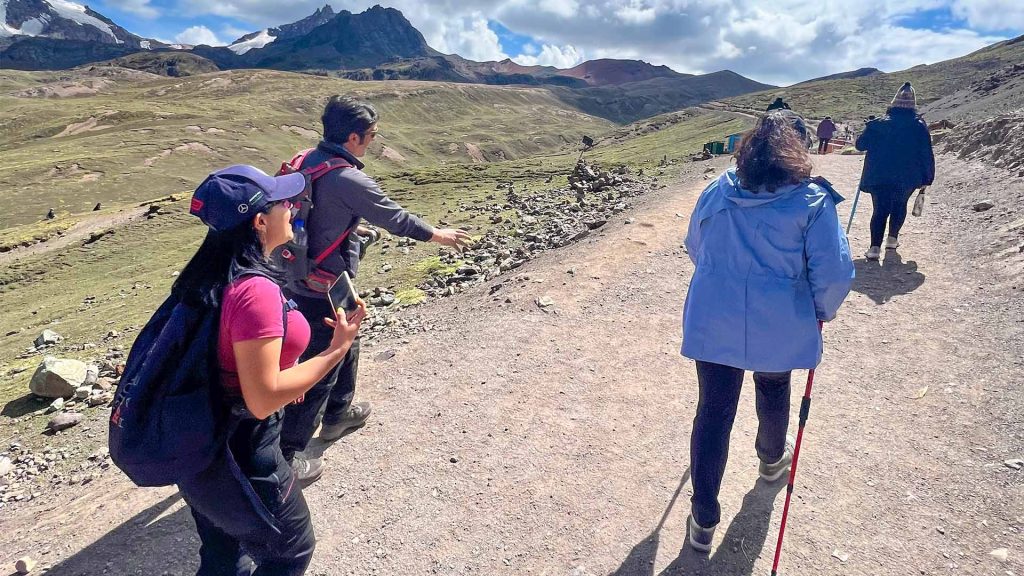
The hike to Rainbow Mountain is considered moderate to challenging. This is mainly due to the altitude and the duration of the walk.
The level of physical effort required to reach Vinicunca is moderate. The hike takes place at high altitude and may cause altitude sickness in some people, so previous acclimatization is recommended. The terrain is mostly flat, with some uphill sections.
We recommend walking at a comfortable pace, staying well hydrated, and taking the time you need to adapt to the altitude.
It is recommended to acclimate for a few days in Cusco before the hike and to bring suitable clothing, water, and energy snacks.
If you wish, you can bring coca leaves. They are commonly recommended to help with altitude sickness and can help you maintain energy during the hike.
To better enjoy this adventure, we recommend bringing:
Altitude sickness, also known as soroche, is a natural reaction of the body when visiting high-altitude areas. To help prevent it, we recommend acclimating and drinking plenty of water in the days before your visit. Coca is also a common option to help with altitude sickness.
The entrance fee to Rainbow Mountain varies depending on whether you are a national or foreign visitor. However, our tour includes entrance tickets to the mountain and an expert guide who will accompany you along the route, from your departure in Cusco until you reach the mountain.
If you would like to go up to the mountain on horseback, you can rent horses directly at the site, at the beginning of the hike or along the route. Horses can only be rented directly from local residents.
To have a better experience, we recommend:
For a long time, we had wanted to visit the famous Rainbow Mountain we had heard so much about, and what better way to do it than with my best friend. We always saw it in photos, but we knew that being there, standing in front of it, would be completely different. So we decided to travel to Peru and make our dream come true. It was a challenge, but it was completely worth it.
From the moment we landed in Cusco, the CuscoPeru.com agency was already waiting for us at the airport, just as they had promised. They were very attentive with us and took us to our hotel. What a relief to know that everything was well organized!
On this first day, we had to acclimate just as the agency recommended, to avoid altitude sickness. So we enjoyed our first day in the city of Cusco and visited places such as Sacsayhuaman, Qoricancha, and the streets of this beautiful city.
The agency guide was very kind and attentive with us at all times. He explained the incredible itinerary we would have the next day and also gave us tips to make the most of our visit to Rainbow Mountain.
The long-awaited day had arrived! It was 4 in the morning, and the vehicle from the agency we hired came to pick us up. The city was still dark and we were sleepy, but the excitement of seeing the famous mountain filled us with energy. We got into the car warmly dressed and with our backpacks. The guide welcomed us and explained the day’s itinerary, so we were more than ready to begin our adventure to Rainbow Mountain.
As we moved farther away from the city of Cusco, the sun began to rise. We could see the first rays of sunlight as the beautiful landscapes were revealed. We were truly delighted by the views while the guide told us very interesting things about the history and culture of Oropesa, Tipón, and Pikillaqta, the towns we passed along the way.
After approximately two hours of travel, we made a stop in Cusipata. Being there, we felt we were getting closer to the mountain. We got out of the car and admired the beauty of this small town.
We had a delicious breakfast that recharged our energy to continue our adventure. While we were eating, the guide told us about the culture of this town and the importance of Rainbow Mountain for the nearby communities.
We continued the journey by car until we reached the starting point of the hike. We were already closer to the mountain. We arrived at Phulawasipata, and as soon as we got out of the car, we felt the fresh air. We saw the surrounding mountains and the snow-capped Ausangate, and everything was impressive. From here, we continued our adventure on foot. As we walked, we observed and learned more about the flora and fauna of the area. What caught our attention the most was seeing the entire Andes mountain range; we felt surrounded by all of it.
On the way to Rainbow Mountain, we saw other people also heading there on horseback. The route was a challenge, but we were determined to arrive because we were finally going to fulfill our dream of seeing the mountain. We had already covered part of the trail, we were tired, and we made our first stop. There, we took the opportunity to take photos, and we knew we were almost there!
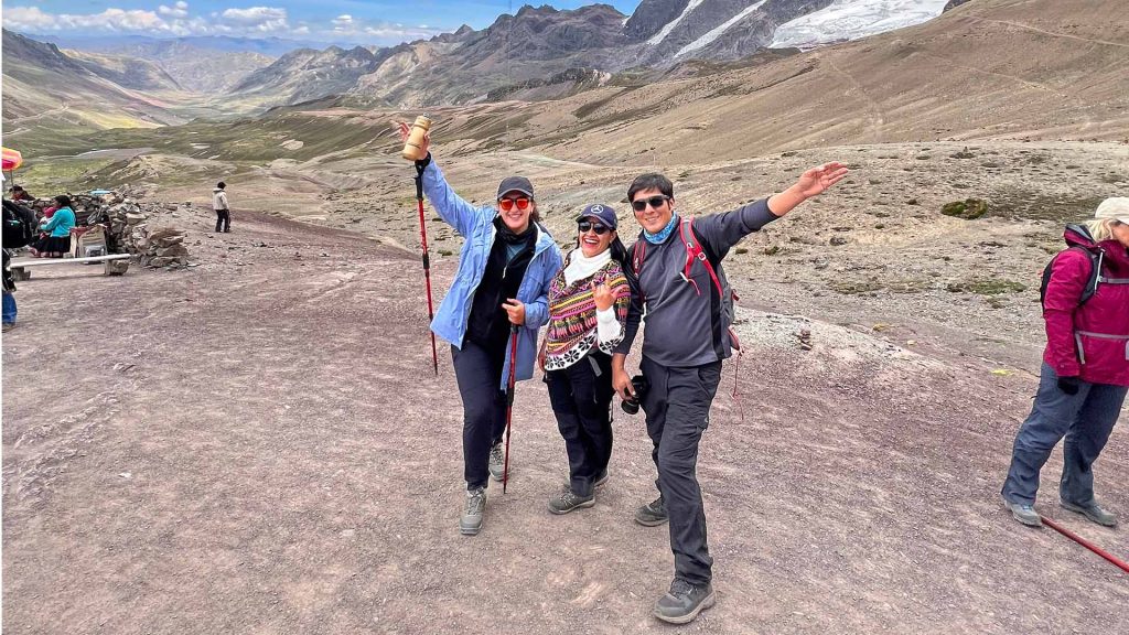
After a challenging climb, we finally arrived. The view was so spectacular that it did not seem real. In front of us stood the impressive Rainbow Mountain. We finally saw it. We admired those colorful stripes that looked hand-painted. We were truly amazed and very happy to have achieved our goal of seeing the mountain.
While we contemplated this natural wonder, the guide explained the geological formation of the mountain, the reason behind its unique colors, and also its spiritual meaning. This mountain, like others, is considered sacred by local residents because it provides protection. For this reason, they are considered “Apus.” Everything was very interesting thanks to our guide’s explanations.
We took advantage of this beautiful panorama to take many photos and remember the moment. In addition to Rainbow Mountain, we were also able to admire the beautiful view of the Red Valley. Everything was truly incredible.
The hike back was peaceful as we shared our impressions of the place with Ángela, my best friend. When we reached the car, we settled in, satisfied and happy, ready to return to Cusco.
On the way back, we rested and arrived in Cusco when it was almost getting dark. We were tired, but very happy because of the incredible memories.
We said goodbye to Cusco feeling very happy and nostalgic at the same time. Without a doubt, it was the best experience of our lives, at the top of the rainbow. We returned to our country delighted to have discovered wonderful places and grateful for the kind people who welcomed us in Cusco, especially the CuscoPeru.com Agency and our guide, who was always attentive to us and shared many interesting things with us. Until our next adventure in Peru!
Children can visit Rainbow Mountain; however, it is important to consider their age and physical condition because of the altitude and the hike.
Yes, during the route you will find bathrooms at certain points along the way.
As for hotels, the closest accommodations are located in Cusipata, a town near the mountain. These hotels are usually simple but welcoming.
Visits take place during the day. Tours generally start very early to take advantage of the best weather conditions and admire the incredible rainbow-colored mountain.
To make the most of your experience at Rainbow Mountain, having a guide is a good option. Our tour includes the service of a guide who will accompany you on this adventure through Vinicunca.
According to myths and stories of the Machiguenga people, the Pongo de Mainique and its surroundings are linked to the spiritual origin of their culture. This territory is also considered a space of connection between the Andean and Amazonian worlds, due to its strategic location in the Urubamba River basin.
The Megantoni National Sanctuary covers an area of 215,868.96 hectares and was officially established by Supreme Decree No. 030-2004-AG. It is located in the province of La Convención, Cusco region, in the central part of the Urubamba River basin and on the eastern slopes of the Ausangate mountain range.

The Megantoni National Sanctuary is located in the province of La Convención, Cusco region. Historically, it was registered as part of the district of Echarate; today, it is mainly associated with the district of Megantoni.
To get there from Cusco, one possible route is to travel by bus to Quillabamba, continue by land toward the Tintiniquiato sector, and then proceed to the Pongo de Mainique. Travel times may vary depending on the season, road conditions, and river conditions.
There are also air access options to nearby communities, such as Timpía, followed by river journeys by boat. Due to the remote location of the sanctuary and the variable access conditions, it is recommended to organize the visit with a travel agency. To book tours and visits to natural areas, consult CuscoPeru.com, an authorized tourism agency that will help you organize your trip in an accessible and safe way.
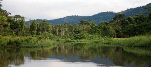
The Megantoni National Sanctuary protects one of the best-preserved areas between the Andes and the Amazon. Its territory connects puna landscapes, montane forests, and lowland rainforest, which explains its great diversity of landscapes, climates, and species.
One of its main attractions is the Pongo de Mainique, a narrow canyon formed by the Urubamba River. Along the route, visitors can observe waterfalls, rocky walls, dense vegetation, and landscapes of great cultural value for the Machiguenga people.
The area is home to significant wildlife diversity, with species such as the military macaw, the Andean cock-of-the-rock, the spectacled bear, the black spider monkey, and other Amazonian primates. It also stands out for its intact forests, water sources, and a wide variety of birds, amphibians, reptiles, and plants.
One of the best-known accommodation alternatives in the area has been the Machiguenga Center for Tropical Studies, linked to the native community of Timpía. It is recommended to verify its availability, operating conditions, and entry requirements in advance.
Kosñipata is part of the transition zone between the Andes and the high jungle of the Alto Madre de Dios, extending from the headwaters of the rivers that form the Alto Madre de Dios hydrographic system. Its altitude varies from approximately 3,678 meters above sea level at Tres Cruces to 650 meters above sea level near the mouth of Pilcopata. Its average annual temperature is 25 °C, with a rainy season from December to April and a drier season from May to November, considered the summer period or a time of low rainfall.
Before the creation of the district of Kosñipata, this area was inhabited by two native communities: the Wachiperi and the Matsigenka. They practiced fishing and small-scale agriculture for their daily consumption.
Pilcopata is one of the most important transit points toward Manu National Park. It stands out for the trade of jungle products, as well as for its lodging services and restaurants. Near the entrance to the National Park, visitors can see remains of Inca roads with their respective channels. There are also petroglyphs representing human figures, animals, and unknown symbols. These artistic expressions extend over a wide area and are of great interest to adventure lovers.
The district of Kosñipata is located southeast of the city of Cusco, approximately 220 km away. The Pilcopata Valley is reached through the town of Paucartambo. From there, the route ascends about 25 km toward Acjanaco and the natural viewpoint of Tres Cruces, before continuing toward the Kosñipata Valley, known in tourism as the land of clouds.
Pilcopata stands out for the trade of jungle products, as well as for its lodging services and restaurants, and for being one of the access points to Manu National Park. Near the entrance to the National Park, visitors can see remains of Inca roads along with ancient channels. There are also petroglyphs representing human figures, animals, and unknown symbols. These manifestations extend over a wide area and are of interest to travelers seeking history and adventure.

Happy passengers