Misti is one of the seven active volcanoes located in the Pilo-Quaternary volcanic chain of southern Peru, belonging to the Volcanic Zone of the Central Andes. The altitude of Misti is 5,822 meters and its slope with reference to the Plaza de Armas of Arequipa is 3,500 meters. The distance from the cathedral of Arequipa to the crater is only 17 kilometers in a straight line. On the opposite side, towards the Altiplano, the difference in altitude is 1,600 meters.
Recent geological-geophysical studies show that the Misti volcano is approximately 800 thousand years old, and that it is located on a base made up of rock formations called "ashlars". These ashlars can be widely observed in the Chili river canyon and throughout the pampa southwest of the Arequipa-Yura highway.
Towards the year 1440 - 1450, the Misti volcano erupts; as a result Inca Yupanqui makes many prayers to the Mountain to appease the wrath of the important Apu, without success.

Misti Volcano is located 17.5 km northeast of the city of Arequipa, within the Salinas y Aguada Blanca National Reserve.
The greatest attraction of Misti is the volcano as a whole, since with its almost perfect conical shape and the shades of snow on its summit, it gives the city of Arequipa a unique scenic beauty in the world.
At the highest point of the crater, there is an eight-meter long rail cross that was placed in 1900 to mark the advent of the twentieth century.
In addition, it is worth mentioning the Aguas Blanca National Reserve, which is home to volcanoes (including Misti), lagoons, and important examples of the flora and fauna of the Arequipa region.
Consult with your travel agency.
The Colca river extends along 450 km on the eastern slope of the Andes mountain range, along its course it changes its name to the Majes river and then becomes the Camana river. The Colca valley corresponds to the first portion of the basin of this river and it is there where the Colca canyon is located.
An important fact to mention is that in 2005, the Polish mathematician and expeditionary Andrew Pietowskidio announced that in the area adjacent to the town of Quillo Orco, in the district of Huambo, the depth of the Colca Canyon reached 4,160 m on the north side and 3,600 m on the south side. A previous measurement made in 1981 gave the depth as 3250 meters.
As for the settlement of these valleys, it is believed that the first inhabitants arrived here about 8000 years ago, as there are remains from more than 5000 years ago in the Sumbay cave. Later, 3000 years ago, a Neolithic revolution took place when the settlers improved their tools and mining techniques. Nowadays, terraces more than 1000 years old are still used for agriculture.

This privileged place is located in the district of Cabanaconde. From this viewpoint you can observe the walls and the bottom of the canyon. In addition, you can often observe the flight of the condor, since they are accustomed to human presence.
From Caylloma to Canco there are hot springs with a maximum temperature of 85 C° at the spring outlet. Among the best known of these are the thermal baths of La Calera, located near Chivay.
The most important and most notable inhabitant is the condor (vulturgryphus), master of the heights and the largest flying bird in the Andes. Also worth mentioning are the LequeLeque (vanellusresplendens), Guallatas (Chloephagamelanoptera), Pariguanas (Phoenicoparrusandinus) and among the mammals we can mention the Andean fox or atoq, the skunk or añas, wild cats or osjos, vicuñas, taruca, vizcacha, wild guinea pig, among others.
The cultural manifestations of the pre-Hispanic inhabitants of the Colca Valley are the terraces, which are gigantic terraces that cover a large part of the valley. Their construction dates back to the time of the Collaguas and Canaguas, others are older and others belong to the Incas.
Schedule by consultant
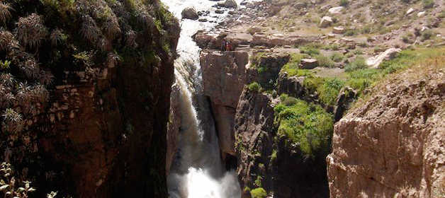
The Cotahuasi Canyon is part of the Cotahuasi Sub-Basin Landscape Reserve, protected by the Peruvian State. According to studies carried out in the area, the valley had pre-Hispanic occupation by Andean cultures such as the Wari, as well as later local settlements. After the Spanish conquest, roads, agricultural terraces, and other farming structures were built. Today, this place is one of the most important natural and cultural destinations in Arequipa.
The Cotahuasi Canyon was formed by the erosion of the waters of the river of the same name, together with the contribution of the Huayllapaña and Huarcaya rivers. It exceeds 3,500 meters in depth in the Ninacocha sector.
This canyon is part of the province of La Unión and is located within the Cotahuasi Sub-Basin Landscape Reserve. It includes twelve life zones and three ecological regions. Along the 100 kilometers that make up the valley, visitors can appreciate different altitudinal zones, each with endemic species of flora and fauna.
Schedules vary depending on the attraction or excursion. To book tours and visits to natural areas, consult CuscoPeru.com, an authorized tourism agency that will help you organize your trip in an accessible and safe way.

Happy passengers