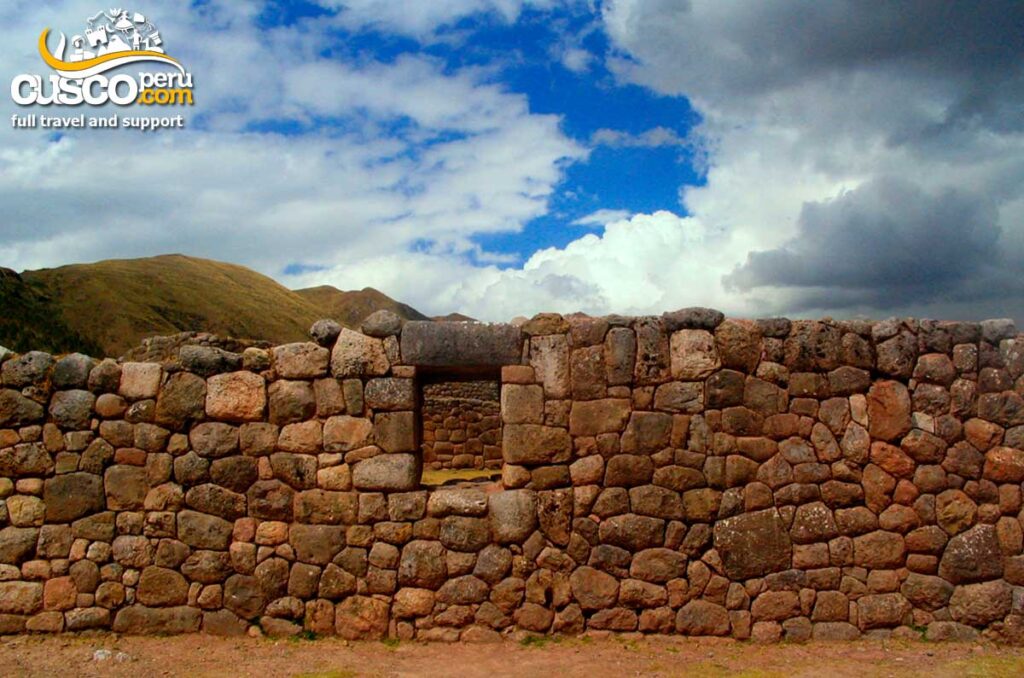
Visiting Taqrachullo, also known as María Fortaleza, allows you to discover one of the most important archaeological sites in Espinar, Cusco. This place preserves evidence of Wari, Qolla/Cana, and Inca occupations, with more than 300 restored archaeological structures, including enclosures, stairways, fountains, kallankas, and walls. From its location, visitors can also enjoy panoramic views of the Tres Cañones de Suyckutambo area. In this article, we explain how to get there, what to see, and what tips to keep in mind to enjoy the experience.
It is an archaeological site with centuries of history. According to research, it was linked to Wari, Qolla, and Inca occupations. It covers approximately 17.4 hectares and contains more than 500 structures, including rectangular and circular enclosures, chullpas, retaining walls, and Inca roads.
Its D-shaped ceremonial spaces and archaeological remains show its cultural importance. It is believed that it may have functioned as a center for surveillance, defense, or territorial control.
At the end of 2024, the site was opened for tourist visits after a restoration process that recovered more than 300 archaeological structures. In recent years, Taqrachullo has gained greater attention thanks to research, restoration, and enhancement works, as it is located very close to the Tres Cañones Regional Conservation Area, created in 2017 to protect 39,485.11 hectares in this highland area of Cusco.

Yes. María Fortaleza is also known as Taqrachullo, which means it can be referred to by either name. The original name of the archaeological center is Taqrachullo, a name that refers to the first ayllus of the area. Over time, during the colonial period, the Spaniards began to rename it María Fortaleza, the name by which the site is known today.
The archaeological site is located in the rural community of Chaupimayo, district of Suyckutambo, province of Espinar, Cusco region. It is located at an approximate altitude of 4,102 m a.s.l.

In this archaeological center, visitors can observe the following elements:

From Cusco, the bus trip to Espinar takes approximately between 5 and 6 hours. From the city of Espinar, visitors must take local road transportation for approximately 45 minutes to Suyckutambo and Taqrachullo.
The Tres Cañones viewpoint is located southeast of the archaeological site and offers a 360° panoramic view of the canyons formed by the Apurímac River and its tributaries. From here, visitors can observe the deep Virginniyoc Canyon, the queñua forests, and the clear sky of the Cusco puna. It is a natural viewpoint from which to admire the Andean landscape in all its magnitude.

The climate in Taqrachullo is cold and dry throughout the year, with an approximate annual temperature of 6.6 °C. During the day, temperatures can reach up to 16.3 °C, while at night they can drop to -4.4 °C.
You can visit María Fortaleza Taqrachullo all year round, but the best time is between May and September, when the weather is dry and there is less rainfall. During these months, clear skies allow visitors to enjoy the Andean landscapes more clearly and take excursions and adventures with fewer weather-related inconveniences.
Some recent publications have compared the size of Taqrachullo with Machu Picchu; however, this information should be presented with caution, as figures vary depending on the source and the area considered.
To visit Taqrachullo, keep the following recommendations in mind:
At CuscoPeru.com, we help you organize tours and visits to protected natural areas in an accessible and safe way. Our travel agents will be delighted to help you plan your visit and enjoy a great experience in Taqrachullo.
Near the historic center of Cusco, there is a place that seems straight out of a magical tale. Surrounded by ancient terraces, vegetation, Inca canals, and a small but charming waterfall, Sapantiana is the perfect place that showcases colonial heritage and Andean spirit. It is a space where visitors immerse themselves in a unique experience that combines history, mysticism, and nature in perfect harmony.
The Colonial Aqueduct of Sapantiana represents a remarkable example of hydraulic engineering from the viceregal era, built over the P’ujru River. Its construction, dating back to the 17th and 18th centuries, was promoted by the Jesuit order along with the Cusco council. This stone structure, composed of arches distributed over four levels, likely reused lithic materials from the nearby Sapantiana huaca. Until before 1950, the channel at the top still carried water for the supply of the viceregal city. Today, it remains a living testament to history, standing firm against the wear of time.
The name "Sapantiana" highlights the spiritual dimension of the place, referring to a sacred space reserved for the veneration of an Inca huaca. The word comes from Quechua, combining “Tiana” (seat) and “Sapan” (unique), which translates to “The place where the huaca sits alone.”
Sapantiana holds a deep history that links the Inca legacy with the colonial era. This structure was part of an ancient network of roads and canals that integrated various agricultural sectors of Cusco. The channel flowing under the bridge belongs to an Inca hydraulic system still in operation, which once supplied terraces, fountains, and cultivation areas. This space has high cultural value, representing the fusion of two construction traditions: the ancestral engineering of the Incas and the architecture brought by the colonizers.
It is located in the San Blas neighborhood, one of the most traditional areas of Cusco, about 15 minutes on foot from the Plaza de Armas. It is situated in a ravine known for its ancient cobbled paths and surrounded by a natural environment that remains almost intact despite its proximity to the city.
Upon arrival, visitors can observe a single-arch stone bridge, covered with moss and wild plants. Beneath it runs a channel of crystal-clear water, and nearby falls a small waterfall, surrounded by ferns and stone walls. The surroundings include:
The sound of water and birdsong make this place a small oasis of peace within the city.
Recommended walking option:
Getting to Sapantiana is quite easy. From Cusco’s central square, head to Triunfo Street, which is to the left of the grand cathedral. Then, walk straight to Hatun Rumiyoc, a narrow pedestrian street where you can see the twelve-angled stone in the Inca wall. Next, enter Choquechaca Street and follow it to the end. Finally, climb the stairs and follow the small stream, as it passes under the colonial arch.
Useful tip: You can also take a taxi to the upper parts of San Blas and then take a short walk.
Best time to go: Dry season (April to October), when the paths are firmer and the weather is stable.
What to bring:
Avoid going at night: There is no lighting on the trail.
Traveler Testimonials
Discover Sapantiana, Cusco’s best-kept secret, and let yourself be carried away by the sound of water, the history in stone, and the magic that only authentic corners can offer.
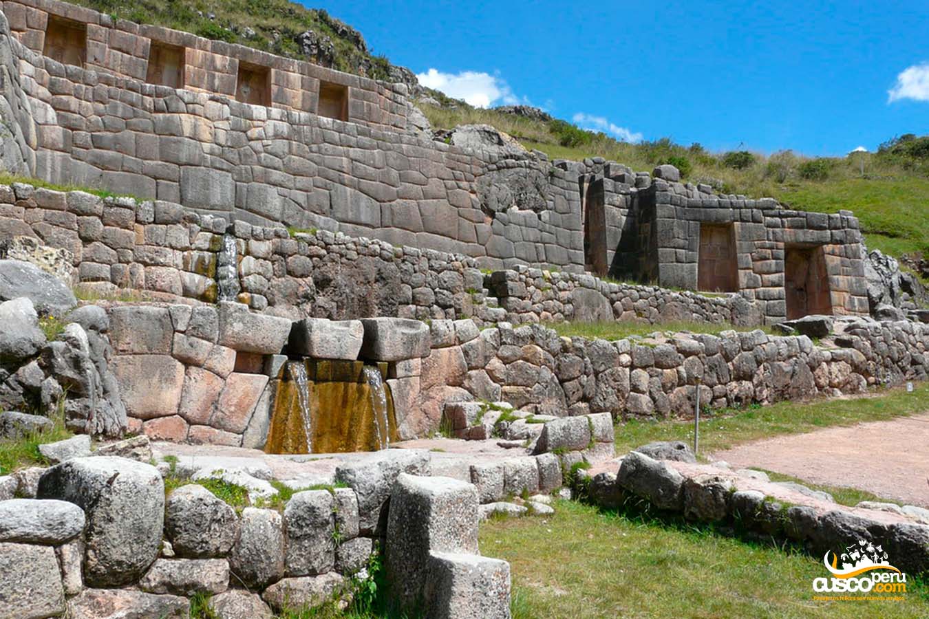
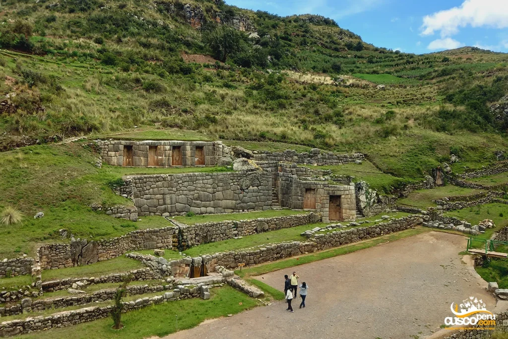
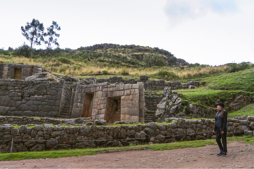
The archaeological site of Tambomachay was a place dedicated to the water worship and as a resting place for the Inca nobility. Today, this archaeological site continues to impress all visitors with its complex hydraulic engineering.
The location has an approximate extension of half a hectare and the material used for its construction was limestone with polygonal style masonry. Tradition knows this monument as "The Bath of the Ñusta" due to the existence of two aqueducts that carry crystal clear water all year round.
[lwptoc]

The name it receives does not have an exact definition, but it is believed to come from two Quechua words: "Tampu" which means lodging and "Mach'ay" which is rest. However, other translations indicate that "Mach'ay" means caves.
In the Andean worldview, water was the origin of life, turning this resource into one of their main deities. For this reason, special importance was given to water worship in all Inca constructions.
Tambomachay has liturgical fountains carved in stone and feed an extensive network of channels that provided water to the nearby archaeological enclosures.
Water worship is present in every Inca enclosure, represented as water channels in which the flow of it is continuous.
This archaeological center was built over a river and springs, although it is still not exactly known where the flowing water comes from. The slope allows water to run through all the channels, which despite having passed more than 600 years, continue to flow.
There is no doubt that all archaeological sites offer a different view of the Inca culture, in this case, Tambomachay shows us the importance that water had in the Inca era.
Tambomachay was not greatly damaged in the era of Spanish colonization, that is why the complex is one of the best preserved, located near the city of Cusco.
Tambomachay is an important example of the hydraulic engineering that the Incas possessed, since the precinct has water channels made of carved stone in which water flows all year round.
This water flows to a platform that functioned as a liturgical fountain and, presumably, the Inca baths.
Tambomachay is located 5 kilometers from the city of Cusco and 0.6 kilometers from Puca Pucara, an archaeological site with which it is closely related. It is on the Cusco-Pisac road.
Monday to Sunday from 08:00 am to 05:30 pm.
Entrance to Tambomachay is included in the Tourist Ticket.
The climate at Tambomachay corresponds to the climate of the city of Cusco, which is generally dry and temperate. However, it is recommended to visit this place in the afternoons, when the temperature is not so high, and you can appreciate why it is named so.
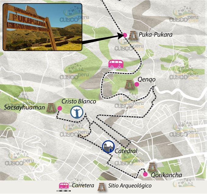
Getting to Tambomachay is very simple, and it offers different options:
Do you want to explore Tambomachay and its surroundings?
At CuscoPeru.com, we have the perfect tour for you.
With our Cusco City Tour, you'll visit Tambomachay, Qoricancha, Qenqo, and other spectacular areas of the city.
Come and experience this unforgettable experience!
Image Gallery
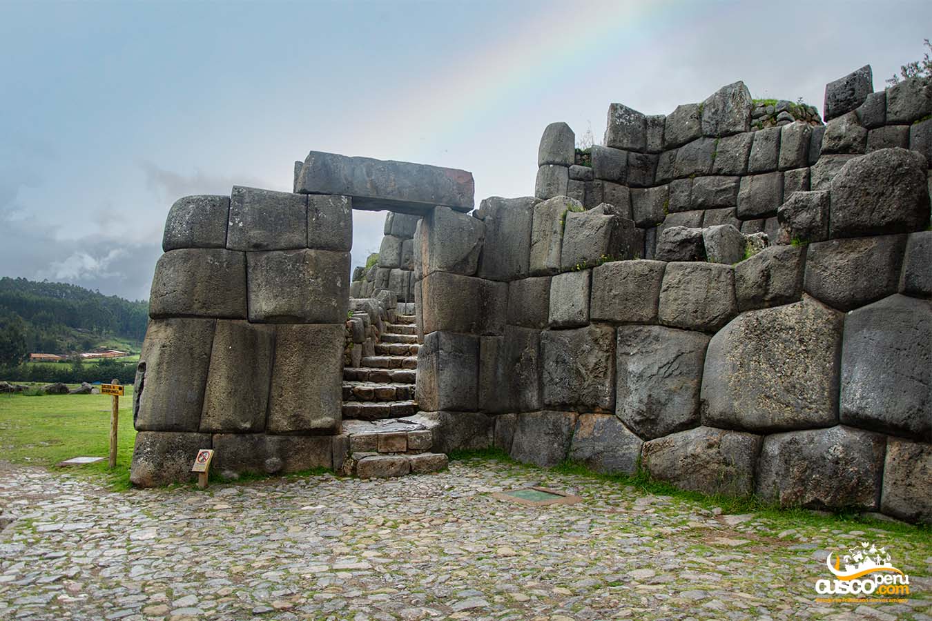
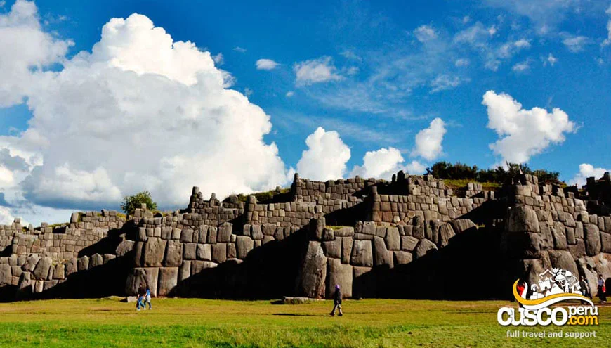
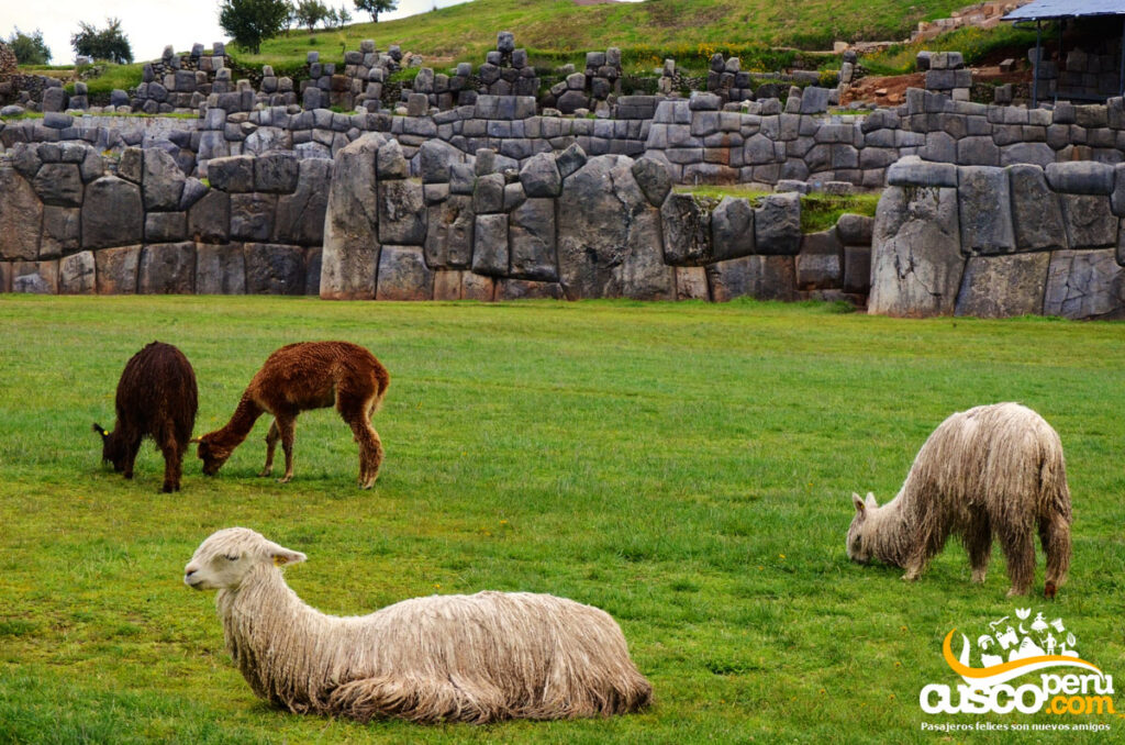
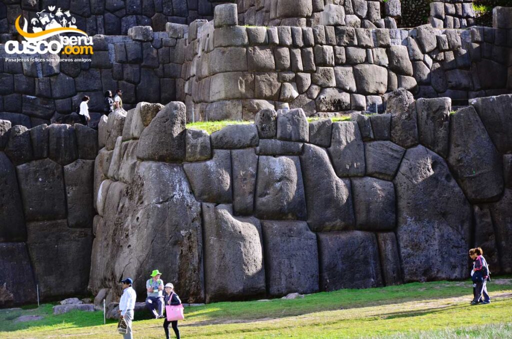
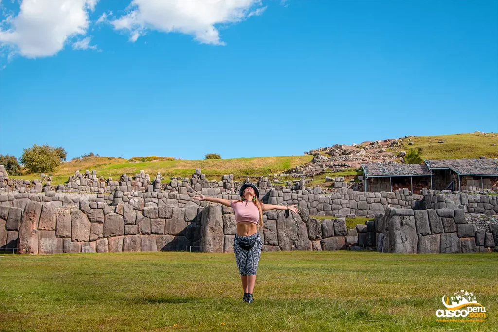
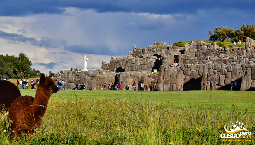
Sacsayhuamán is a work of Inca architecture and engineering built between the 14th and 15th centuries. It became an important place after the llaqta of Qosqo and was named “The House of the Sun of Hanan Qosqo.” Its structures blend harmoniously with the topography and surrounding landscape.
[lwptoc]
Before the Inca expansion, the area was inhabited, according to studies, by the Killke culture. The construction of the Inca fortress was begun by the Inca Pachacutec around the year 1350 A.D. and completed by his grandson, the Inca Huayna Cápac.
It is believed that its construction lasted more than 90 years, and that more than 20,000 men were needed to build this important fortress under the mita system (collective labor). The fortress is one of the greatest examples of the organization and technique of the Inca Empire.
With the arrival of the Spaniards, Sacsayhuamán became a battlefield, serving as a key point for Inca resistance. After the battles ended, this place was dismantled and its stones were reused for the construction of churches, such as Cusco Cathedral.
Over time, Sacsayhuamán lost importance until it was abandoned and was even used as a quarry for the construction of local homes. It was not until 1983 that the city of Cusco, including Sacsayhuamán, was inscribed as a UNESCO World Heritage Site.
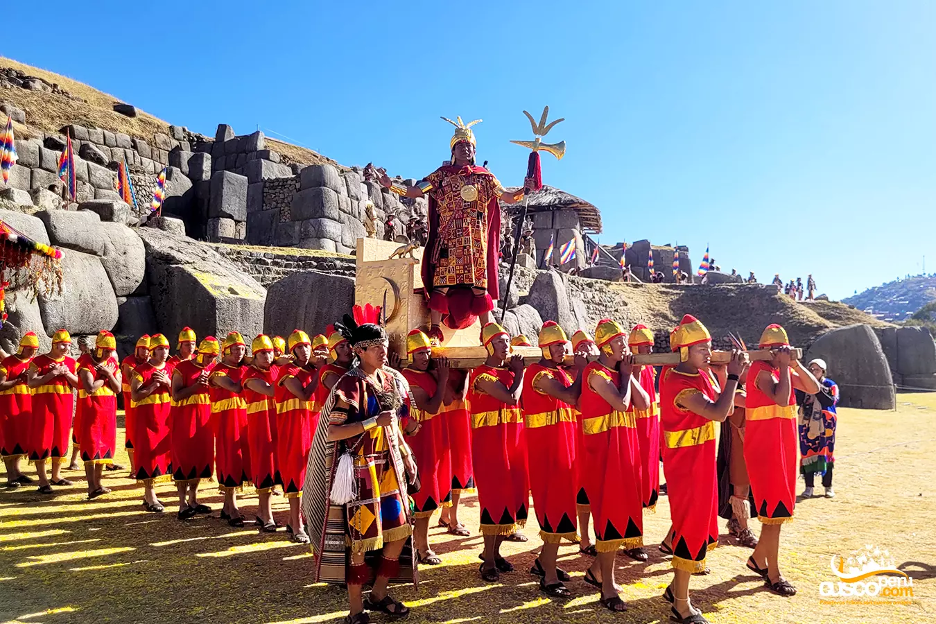
The reenactment of Inti Raymi began in 1944 and, to this day, it continues to be celebrated every year in the same place.
The word Sacsayhuamán comes from the Quechua words Sacsay, meaning “Satisfied,” and huamán, meaning “Falcon,” which in Spanish interpretation would be “The satisfied falcon.”
The Festival of the Sun was a ceremony that formed part of their religion and took place every winter solstice, during which offerings and sacrifices were made in honor of the sun god.
The Incas used astronomy to create their calendar and to know when the dry or rainy season began, as well as to determine the beginning of the harvest season, thanks to the observation of the sun’s position when solstices and equinoxes began.
Sacsayhuamán was initially built with a religious purpose, in honor of the god Illapa, “the god of thunder,” among other deities worshipped by the Incas. However, after the arrival of the Spaniards, it became a battlefield and was referred to by them as a “fortress.”
The park itself contains important architectural and natural features, each with its own meaning and history, such as:
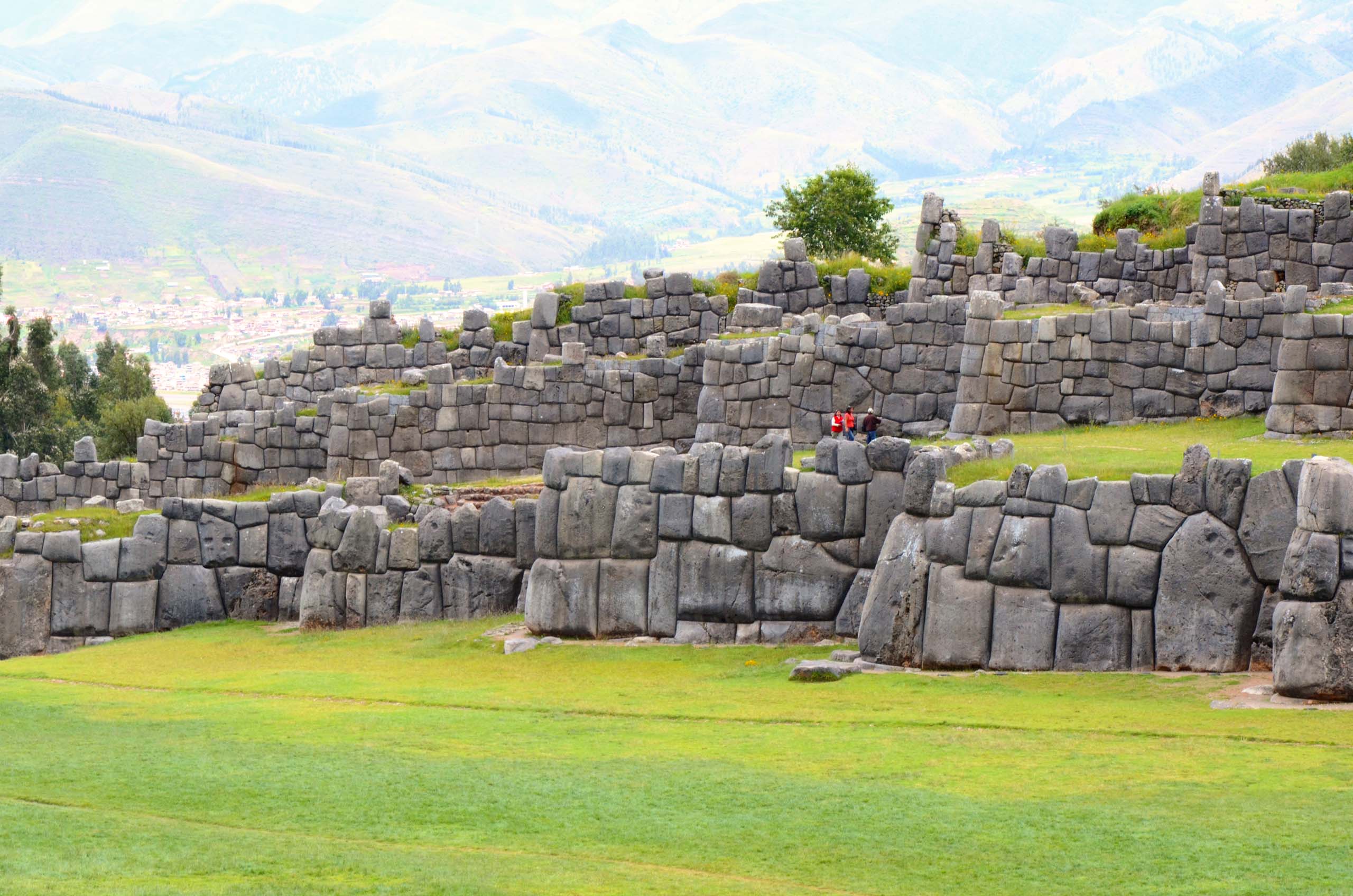
They are known as Muyucmarca, Paucarmarca, and Sallaqmarca, and they are located in the upper part of the bastions (zigzag walls). In Inca times, they were towers arranged in a straight line at the top of the hill. There was abundant water at this site, and today you can still see part of the aqueducts.
Today, only the foundations of the towers remain. The buildings were destroyed in the early colonial period, and their foundations were covered with earth; they were later located and recovered by Dr. Luis E. Valcárcel.
This group of enclosures is located at the top of the hill, to the south and a short distance from the towers. These are rooms set against the hillside, overlooking the plazas of the Inca city. The rooms themselves are characterized by being long and narrow, connected to one another by a series of trapezoidal doorways. Their walls are made up of irregular polyhedrons, with rough faces and finely polished edges.
This name is given to the three platforms that form a toothed pattern of recesses and projections made up of walls built from limestone blocks, with fitted irregular polyhedrons that match each other perfectly.
Located in the central and middle part of the bastions with trapezoidal shapes, they served as entrances to the tower sector. The three gates mentioned are: T’iopunku, Ajawanapunku, and Wiracochapunku.
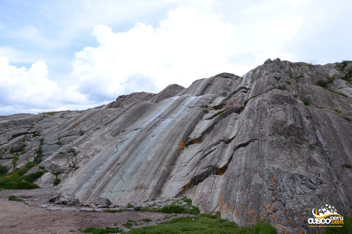
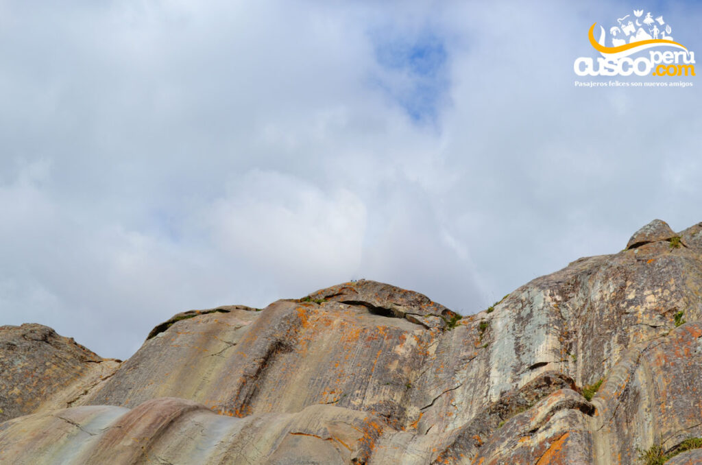
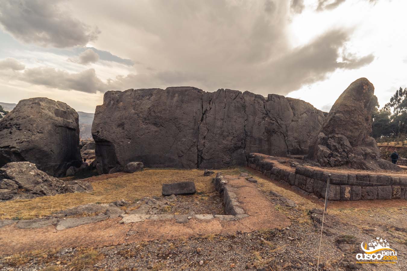
Geologically, it is a natural formation of diorite, of volcanic origin, that emerged with rounded surfaces and grooves like slides.
These words are interpreted as “where the monkey climbs.” It is a succession of seats carved into diorite rock with a deep aesthetic sense. It is located on the eastern portion of the hill, from where there is a panoramic view of the complex.
There are two of them. The smaller one, next to Warmi K’acchana, is short in length and has become an attraction for visitors. The large one is farther north, beneath a large limestone rock. This passage is flooded, and entry is not possible.
There are many rumors regarding the origin of the chincanas, about why and for what purpose these so-called “labyrinths” were built. Some believe they are interconnected with different Inca constructions; however, they remain a great mystery.
There are dozens of legends once told by Cusco locals, as well as written accounts by chroniclers such as Inca Garcilaso de la Vega, about the connection Sacsayhuamán had with Qoricancha, or the sudden appearances of the ancient inhabitants who lived in Cusco.
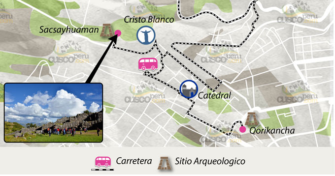
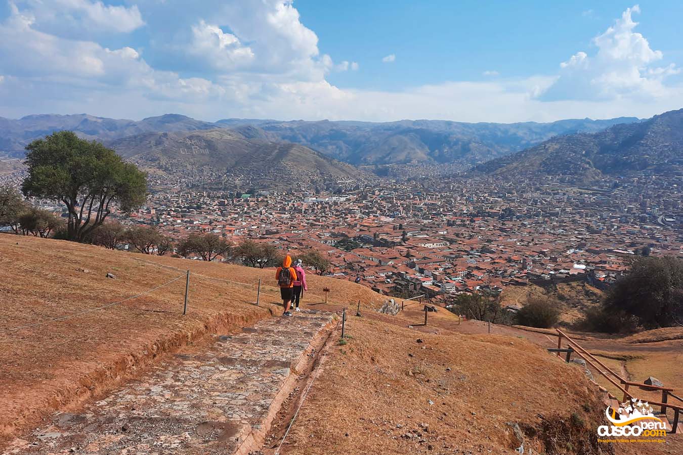
Sacsayhuamán is an archaeological center located north of the main square of the city of Cusco. To get to Sacsayhuamán, you can take a City Tour.
To walk to Sacsayhuamán from Plaza de Armas, you can go up Suecia Street through Huaynapata and continue along Resbalosa, turn right after San Cristóbal Church, and follow the road. Here, you will join the ancient Inca route to Sacsayhuamán. The climb is steep and takes approximately 30 minutes from Plaza de Armas.
The Inca fortress is divided into sectors: Sacsayhuamán, Rodadero, Inca Throne, Warmi K’ajchana, Inca Bath, Amphitheaters, Chincana, and Tower Foundations, among others.
The climate in the city of Cusco is very variable, with the rainy season during the months of December, January, February, and March, and the dry season during the months of May, June, July, and August. However, due to the altitude at which Sacsayhuamán is located (3,700 meters above sea level), it usually has a cold climate. It also depends on the month in which you want to visit this incredible place.
Today, Inca reenactments are held on the esplanade of the Sacsayhuamán fortress.
Every June 24, on the esplanade of Sacsayhuamán, Inti Raymi, the worship of the sun god, is celebrated. It was a very important festival in Inca times and continues to be celebrated today.
It is one of the most important festivities of the year, as travelers from all over the world gather to be part of the Inti Raymi reenactment.
Monday to Sunday from 07:00 a.m. to 5:30 p.m.
Admission to Sacsayhuamán is included in the Tourist Ticket.
Getting to Sacsayhuamán is very easy, and it offers you different options:
Image gallery

The Temple of the Sun - Qoricancha was originally named “Inticancha or Intiwasi,” which would mean House of the Sun, a religious enclosure built in 1200 AD under the order of Inca Wiracocha.
With the arrival of Inca Pachacútec to power, the entire city of Cusco underwent a beautification process. During this period, Inticancha was renamed Qoricanca, and enormous walls were built around it, adorned with gold, silver, and precious stones.
With the arrival of the Spanish invasion, the Temple of the Sun was looted and destroyed. According to some historians, the gold belonging to this site was transferred to Cajamarca to pay the ransom of Inca Atahualpa.
The temple became the property of Francisco Pizarro, who gave it to the Dominican order. They demolished what was left of the Qoricancha Temple to build the Church of Santo Domingo. The construction suffered three earthquakes (1650, 1749, and 1950), completely damaging the Church of Santo Domingo; only the Inca walls remain intact.
In 1956, the reconstruction of the Temple of the Sun - Qoricancha began, prioritizing the exhibition of the Inca walls.
According to many chroniclers, the first to build a temple in honor of the sun were the original inhabitants of Cusco, the “Ayamarcas,” initially calling it “Inticancha.” This ethnic group inhabited Cusco around the 13th century, before the expansion of the Inca Empire. They had a great rivalry with the Incas, but they were defeated and annexed to the Tahuantinsuyo during the reign of Inca Wiracocha.
Koricancha, Qoricancha, or Coricancha would be understood in Spanish as “Temple of Gold,” deriving from the Quechua words Quri “Gold” and Kancha “Temple.”
We can also say that “Qori” means worked gold, with its Spanish form being Cori. “Kancha” means enclosed site, limited by walls, with its Spanish form being Cancha.
Thus, we can say that the name means “Enclosed site containing gold.”
The Qoricancha Temple was a site dedicated to the worship of the Incas' main deity, the Sun. In addition to the Temple of the Sun, this place has four other small temple complexes dedicated to deities such as the Goddess Killa; the moon, the God Illapa; the lightning, the God K'uychi; the rainbow, and the Goddess Chack'a, the star.
All these complexes had a continuous strip of pure gold three meters from the ground that connected each sector. Similarly, the wire that held the thatched roofs of the enclosures was made of gold. The walls were built with perfectly interlocked natural stones, as seen in other Inca constructions.
Qoricancha is located in the city center, at the intersection of Av. El Sol and Santo Domingo Street, just two blocks from Cusco's Plaza de Armas.
A comfortable and enriching way to discover this impressive place is by joining our City Tour in Cusco, which includes a visit to Qoricancha, transportation, and a professional guide. [Cusco City Tour]
The description made by Garcilaso harmonizes with what still stands today. Although it is only a pale reflection of what Qoricancha was in Inca times.
It was the Main Temple of all Qoricancha, occupying more than half the width of the current Church of Santo Domingo. Garcilaso recounts that within this temple were the embalmed bodies of the children of the Sun, placed in order of antiquity on chairs and golden tables. The walls were covered with gold plates, and there was a disk representing the figure of the Sun made of a thicker gold plate than the other plates covering the temple. The western end corresponds to the current drum overlooking Av. Sol; its eastern end reached the current atrium of the church.
This temple was closer to the Temple of the Sun, as the Moon was considered the Sun's wife. This building was lined with silver planks, and there was a representation of the Moon made of silver. Inside, the mummies of the Coyas were kept, placed in order of antiquity. Approximately half of the Temple was demolished by the Spanish to build the nave of the Church of Santo Domingo. It occupies part of the western side of the Qoricancha's inner courtyard.
It is located near the Temple of the Moon but separated by a beautiful alley, dedicated to Venus and the seven sisters and all other stars. The Incas called Venus “Chasca,” meaning star. In this temple, the Inca was placed, according to historians' references, to be deified or to witness festivals or sacrifices performed in the rectangular courtyard. It occupies part of the western side of the Qoricancha's inner courtyard.
Illapa or Chuki Illapa means lightning, thunderbolt, and thunder. The mentioned temple is in front of the temple of Venus, with three simple jamb doors, equidistant and slightly trapezoidal, and also has a window on each side wall.
In this temple, the Rainbow, believed to come from the Sun, was worshiped. It has identical architectural features as the Temple of Illapa. Part of this temple was demolished by the Spanish to build the buildings of the Dominican Convent. It is located north of the Temple of Illapa and in front of the Temple of the Moon, on the eastern side of the Qoricancha's inner courtyard.

Almost all towns in the world, in all eras, built large plazas in front of their temples. Inti Pampa (translated as Plain of the Sun) is where the nobles, their courts, service personnel, dancers, etc., would stay when the Inca and the nobility moved to Qoricancha during festivals. This site now corresponds to the Plaza of Santo Domingo, and its boundaries and extent have hardly changed. It is located north of what was Qoricancha.
It became the great repository of offerings brought from all the subjugated and confederated nations for the Sun God. The offerings consisted of representations of flora and fauna of Tahuantinsuyo. According to some historians, these offerings made of gold and silver were life-sized and filled the area impressively.
The Spanish called it The Solar Garden due to the number of terraces. In the colonial era, it became the orchard of the Dominican Friars. It is located on the western side of Qoricancha and can be seen in its entirety from Av. Sol.
There were five water fountains, and the origins of the water sources were a well-guarded secret. The fountains had religious significance and were decorated with precious metals. They were located throughout Qoricancha, and today we can see an octagonal fountain in the Qoricancha courtyard.
The Temple of the Sun is open Monday to Saturday from 09:00 a.m. to 5:00 p.m. and Sundays from 2:00 p.m. to 5:00 p.m.
GENERAL ADMISSION is S/.15.00 for foreign or national tourists. The entrance is not included in the Tourist Ticket.
*Please note that with your ticket, you can visit the Qoricancha temple without a time limit.

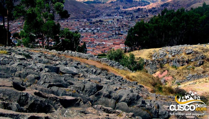
The archaeological complex of Q’enqo, located on the outskirts of the city of Cusco, was an important Inca religious site where ceremonies were held in honor of the gods of Inca culture.
What remains today of the archaeological complex of Q’enqo are carved rocks that could not be destroyed by the Spanish. Little remains of the paths and aqueducts, and the enclosures, storage areas, and ceremonial spaces are no longer there.
The translation of the word Q’enqo or Kenko would be “labyrinth,” in reference to the tunnels, passages, and underground channels found in this place. During the colonial period, the name “Q'enqo” would have become established, while in Inca times it was traditionally known as “Q’inqu.”
It is located on the outskirts of the city of Cusco, on Socorro Hill, at 3,580 meters above sea level, about 3 to 4 km from the city center.
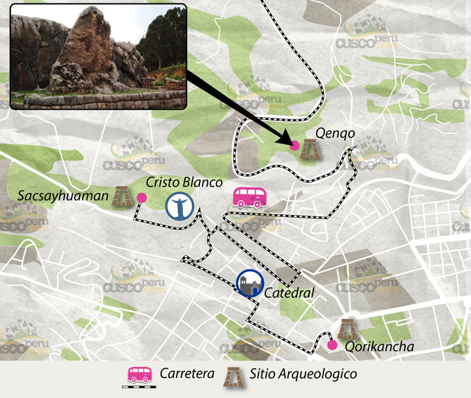
Q’enqo is entirely carved into a natural rock formation. The religious importance of this site led to its destruction during the Spanish colonial period; however, because it was completely made of stone, it managed to withstand the attacks.
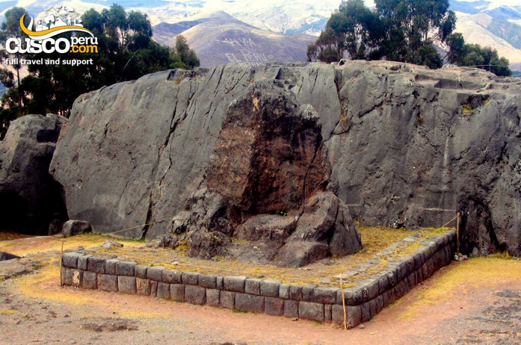
Inside, three important animals from the Andean worldview are carved and interpreted as the condor, the puma, and the serpent.
It is made up of two main areas known as Q’enqo Grande, which is the largest rock formation, and a smaller rock called Q’enqo Chico.
It is located on the upper part of the large rock and consists of two cylindrical stone projections that rise vertically over an almost elliptical pedestal, all carved into the top of the same rock.
The use of intiwatanas, meaning “where the sun is tied,” during the Inca period remains a mystery. It is believed to have been a type of astronomical observatory used by the amautas to measure time, establish the seasons, determine the solstices and equinoxes, and also as a place of worship where the sun, moon, and stars were honored.
With the arrival of the winter solstice, the first rays of the sun fall directly on this place, forming a figure that resembles a puma with bright eyes.
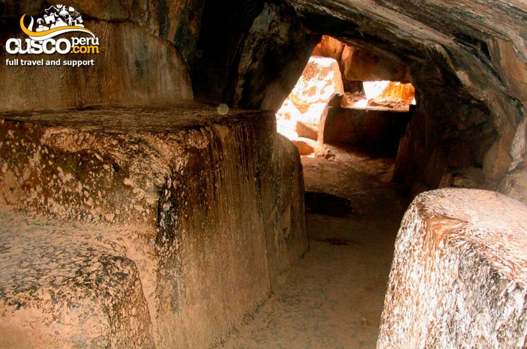
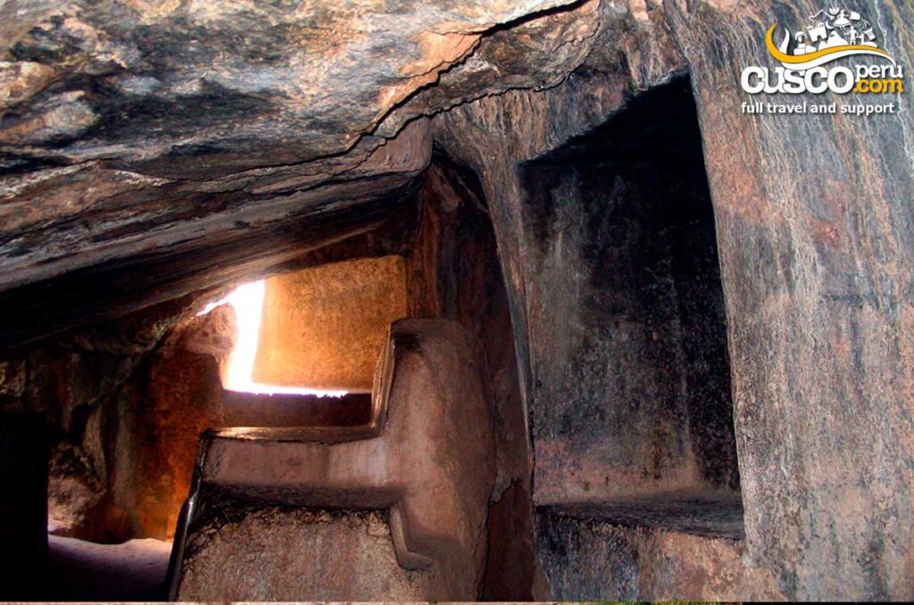
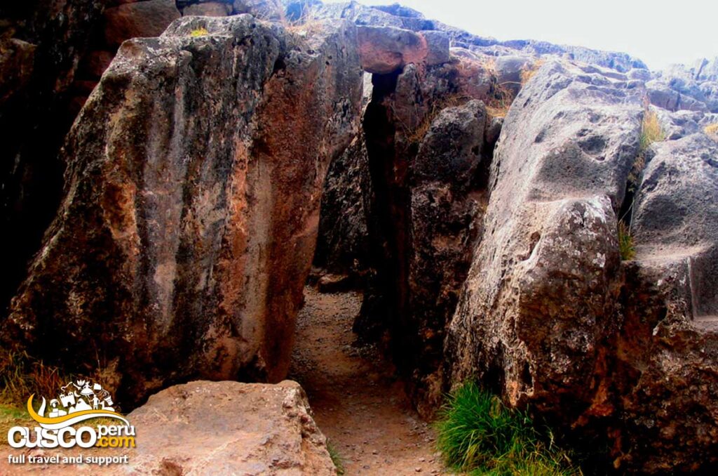
It is an underground chamber with its floor, ceiling, walls, tables, and niches carved into a single gigantic rock. It is said that this underground chamber may have been used to embalm the bodies of Inca nobles, as well as for human and llama sacrifices.
Because it is underground, it symbolized the entrance to the world of the dead.
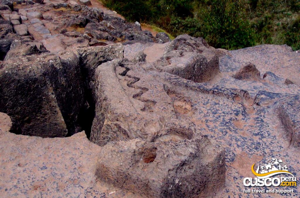
Located on a large rock and very close to the Intiwatana, the zigzagging channel begins from a small hole and descends along an inclined plane in a broken line. It then splits into two branches, one of which led the liquid to the underground chamber or Sacrifice Chamber (according to Cusco historian Víctor Angles). It is believed that it may have carried ritual liquids, such as chicha or other liquid offerings.
This is a huge semicircular area 55 m long, with 19 unfinished niches distributed along the wall. During the Inca period, this place was a temple for public ceremonies. In front of the open area, there is a large 6 m-high stone block resting on a solid rectangular pedestal.
It has niches distributed around the amphitheater like seats, but according to recent research, it is very likely that they were actually the bases of a large wall, with each one representing an entity that was worshiped.
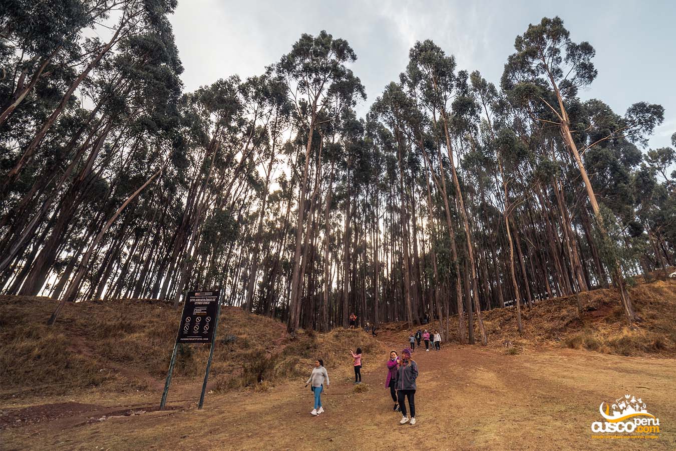
The Q’enqo forest is made up of imposing eucalyptus trees where you can take photos as a memory of your visit. Entry is free, and it is located just a few meters from the archaeological site.
Monday to Sunday from 8:00 a.m. to 5:30 p.m.
The entrance fee is included in the Tourist Ticket.
Since it is located just a few kilometers from the city of Cusco, you can reach Q’enqo in several ways:
Would you like to discover Q'enqo in a deeper and more enriching way? At CuscoPeru.com, we offer personalized tours that allow you to learn the secrets of this impressive archaeological site, accompanied by expert guides who will explain its history, symbolism, and connection with other Andean cultures. Our tours also include visits to other fascinating places in the Sacred Valley and Cusco, creating a complete and unforgettable experience. [Machu Picchu + Sacred Valley], [Machu Picchu + Rainbow Mountain]
Image Gallery
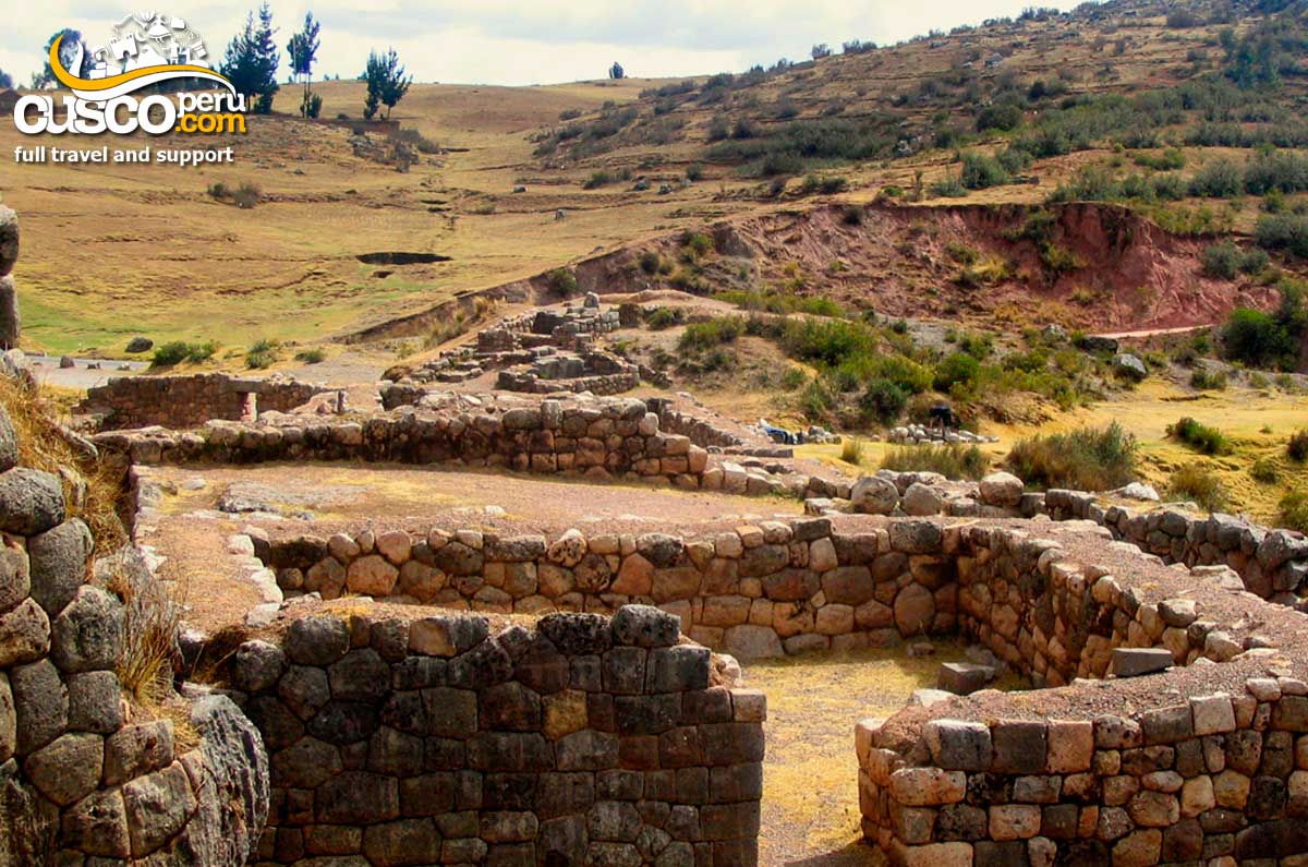
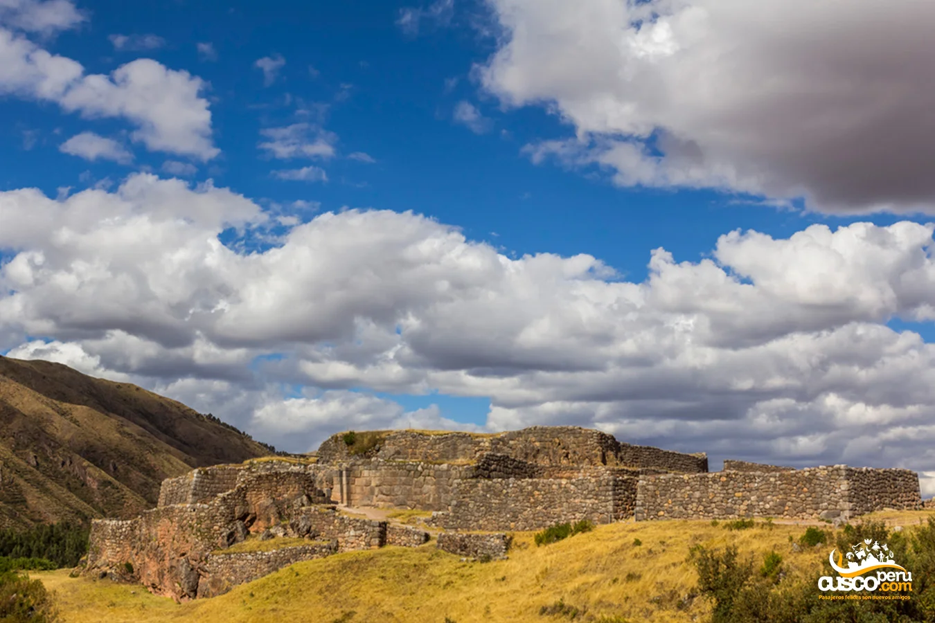
Puca Pucara is one of the most important archaeological complexes in Cusco, alongside Sacsayhuaman, Q'enqo, and Tambomachay.
Its architecture demonstrates the advanced Inca technology, although the lack of perfect finishes suggests that this site was not of significant religious importance. However, it was of great importance for the Inca messengers and the royal guard.
[lwptoc]
Its construction was initiated by a culture prior to the Incas; however, it was under Pachacútec's reign that the infrastructure was improved.
Traditional information indicates that when the Inca was set to visit the Baths of Tambomachay, the formidable entourage of soldiers stayed in Puca Pucara, which served as a barracks and tambo. It is said that the chincana (underground tunnel) existing at the site directly connected to Tambomachay, although this is unproven.
The name Puca Pucara comes from two Quechua words meaning "Puca or Puka" red and "Pucara" which is fortress. Its translation would be Red Fortress, receiving this name due to the reddish hue its walls acquire in the evening.
The Archaeological Center of Puca Pucara is located on the upper part of the road leading to Pisac, about 7 km from the city of Cusco.
To get there, you can take a City Tour from any travel agency. Additionally, you can reach it by foot after visiting Tambomachay, as it is just a few meters away from the Inca baths.
This archaeological complex features terraces, walls, aqueducts, squares, and stairways that ensure the urban layout is suitable and functional. The buildings are made of stones of various sizes, with the surface of the rocks being very rugged and scarcely worked, compared to other archaeological sites.
The structure was built using limestone native to the area, mostly medium and small stones, all joined with great precision, making it resistant to various seismic movements.
The complex includes three walls with irregular floors, built across three levels on the same site.
Located at the lower part of the archaeological complex, this first wall has a sinuous layout carefully avoiding cutting through protruding rocks. To the north and behind the outer wall, there are six rooms of different sizes, built irregularly to avoid touching the rocks forming the wall.
The second wall encircles the central elevation. Between this and the first one, there are very broad platforms. On the second level, we find terracing and gardens facing south, and to the east, there are three rooms with trapezoidal plants and one rectangular.
This level is situated at the highest point. Currently, no Inca remains can be observed due to the passage of time; however, it offers an incredible view of the entire place.
Monday to Sunday from 08:00 am to 05:30 pm.
Entrance to Puca Pucara is included in the Tourist Ticket.
The climate at Puca Pucara matches that of the city of Cusco, generally being dry and temperate. However, it is recommended to visit this site in the afternoon when the temperature is not so high, and you can appreciate why the place is named as it is.
Reaching Puca Pucara is very simple, and it offers different options:
Image Gallery

Happy passengers