Here we describe the archaeological groups that are located on the left bank of the Urubamba River between the slopes of the hills and the short riverside plain. Despite the passage of time, the flooding of the Urubamba River and other natural events, you can still see terraces, enclosures, shrines, observatories and others.
Located on the right bank of the Urubamba River, between kilometers 95 and 121 of the railroad line to Machu Picchu.
It is located at Km 95 of the railroad line to Machu Picchu, in a sector boxed in by the mountains. What remains of this archaeological group is a set of platforms with walls parallel to the river, and remains of roads that linked this group with others.
Archaeological group located in a, it is at the height of the Km. 104 of the railway line that goes in the opposite bank. This group must have been a population center of relative importance, but the main shrine of the sector. In this group we can find: Eight liturgical fountains, six liturgical fountains, an adoratory sculpted in a gigantic rock, two plazas one North and the other South, a main building and two terraces.
It is located at Km. 107 of the Cusco - Machu Picchu railroad line, it covers both sides of the creek of the same name. At present there are about twenty-five enclosures of different types; we find a very tall main building and the best decorated, in front of this a semicircular platform as a square and to finish a succession of platforms.
It is located to the west of the Inca city of Machu Picchu, at the height of Km 121 of the railroad line Cusco - Hydroelectric of Machu Picchu, very close to the western base of the mountain of Machu Picchu. This group includes the entire western slope of the mountain and in it we can see: The shrine and observatory with certain archaeological units such as the lithic gnomon carved into the rock, a water regulating device, as a spout, a huge anthropomorphic sculpture. In addition, we can find enclosures and platforms.
These groups are located immediately after the archaeological groups that comprise the archaeological complex of Q'ente on the route to Machu Picchu via the Inca Trail. Travelers will be able to appreciate them from the second day of trekking (on the Classic Inca Trail). In these archaeological groups can be seen, platforms, enclosures, shrines, aqueducts and much more.
They are located in the Urubamba basin, along the Inca trail.
This complex begins after passing the Kusichaka bridge, continuing along the Inca Trail along the route of the mountains from north to south. Throughout the complex we find archaeological groups with different types of archaeological remains such as: ancient enclosures, a short set of terraces and vestiges of an Inca canal.
Wayllabamba is a peasant community and Patawasi is the upper portion of the land. In this set we find incomplete walls and platforms, some rustic tombs and fragments of aqueducts.
Possibly it was a tambo, from Wayllabamba walking along the creek upstream and after two kilometers we arrive at the junction of two streams that form the Wayllabamba, here is the community of Pauqarkancha. Half a kilometer up there is a group called Inkaraqay very peculiar and unique in its shape, it looks like a snail or a cone of circular ornaments that has walls and houses overlooking the creek and rectangular patios.
Ascending from Inkaraqay through the ravine of the Qesqamayu stream that forms the Wayllabamba together with another stream, we advance approximately 800 meters and arrive at the Inkasamana site, which is a small archaeological group with vestiges of terraces, 5 km ahead we find another group that has two enclosures separated by a rectangular courtyard.
It is located in a spectacular prominence of land; it was a tambo, watch post and ritual station. From here you can see Warmiwañuska, it is a circular walled complex, it has a rectangular enclosure in front of it, after 30 minutes or 3 Km. away we arrive at the Runkuraqay pass. From here half a kilometer we find some scattered lagoons.
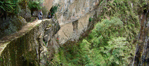
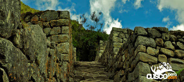
From the lagoons of Runkuraqay we advance 1 Km. and we find the archaeological group called Sayaqmarka, it is like a puzzle for its narrow streets and enclosures arranged in different planes, liturgical fountains, patios and canals.
Leaving Sayaqmarka, walking more or less 3 kilometers, we arrive to a tunnel of 20 meters drilled in the granite rock with staircases in its interior, Phuyupatamarka was a sector destined to the cult and dwelling of the nobles. We can find the following architectural samples: Four groups of houses with a total of fifteen buildings, six liturgical baths, staircases, three caves, water channels, canalizations, terraces and passages, three squares, the main door, a sacred rock and the royal road.
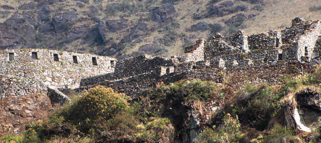
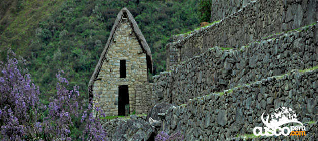
It is a compound Quechua word that means always young, the monument is located in the middle of the mountain, above Choquesuysuy. Here we distinguish: An urban sector with about twenty enclosures of amazing distribution, the group of the tower that occupies the upper portion of the whole set, the liturgical fountains located on the right side of the set, the sector of the platforms that could be called agricultural sector.
It is translated as site where the sun rests, is a huge set of platforms with several groupings of enclosures. It is on the same flank of the mountain that houses Wiñaywayna.
The Toronto complex includes 7 archaeological groups and is in front of the Q'ente Complex, separated only by the Urubamba River, possibly they were independent chiefdoms with a strong economic bond.
The aforementioned archaeological groups are distributed in the first part of the Inca Trail, on the border of the Machu Picchu Historic Sanctuary.
We can find 7 archaeological groups:
Torontoy: The local farmers call it Inkaperqa or Inca raqay, alluding to what they see. In this place we can find a main doorway, several groups of enclosures, patios or free areas separating the buildings, vestiges of a liturgical bath and a central enclosure with a lithic piece of more than 40 angles that joins other twenty-eight pieces with exact interlocking in the joints.
It means hall door, because what is most obvious is a wide door that is on a platform that runs as a street in front of the wall. Behind the door we find cyclopean platforms and plains with remains of stairways, interior roads and remains of aqueducts.
It means pampa where the grass "qhana" grows. It is at the height of Km. 85 of the railroad line. We can find a series of one-story buildings and a two-story building which is the largest.
It means windy door (alluding to a windy place). In this group we find remains of buildings and a partially standing enclosure, there are vestiges of aqueducts, paths and overcrowding of canted stones that were part of constructions.
Here were made the best hydraulic works of the zone, the crystalline waters that descend, appear channeled by wide lithic channels; also we find from the bank of the river a succession of parallel platforms, a road that leads to an adoratory carved in the rock insitu, ascending some houses and an observation tower.
It means gold winnowing. We can find the following: A huge staircase with more than one meter wide, semicircular ramparts, platforms as retaining walls and a vertical slope worked that is on the turbulent waters of the river.
It means that it has broom, in this group we can find long platforms with semi-cyclopean walls, tombs that are desecrated at the base of the mountain and others intact.
Starting from the eastern end of the complex, approximately at Km. 84 of the railroad line, there are 9 archaeological groups that spread up to Km. 90 of the same line.
The aforementioned archaeological groups are distributed in the first part of the Inca Trail, on the border of the Machu Picchu Historic Sanctuary.
We can find 9 archaeological sites:
It is made up of short platforms of rustic structure; there are vestiges of rustic dwellings with a base of small, edged lithic stones.
This group includes the archaeological units Leyonniyuc, Olleriayuc and Tunasmoqo, with rustic adobe constructions with a stone base.
It has more than 30 enclosures placed in singular symmetry; we find a semicircular tower in the westernmost part of the complex.
In this archaeological group, which covers both banks of the Kusichaka stream, we can highlight archaeological monuments, the bridge, semi-ruined terraces, tombs, aqueduct and roads.
It is more than one kilometer long. In this complex we can appreciate: flat terraces, straight roads, blocks of well laid out buildings, shrines, surveillance and communication points.
Over the river we find the remains of an Inca bridge over which a new one was built. In front of the village there are ancient terraces as retaining walls.
We found two enclosures associated with platforms. Next to a waterfall, at the base of the mountain and very close to ancient platforms, there is a rock carved with straight moldings.
Encontramos una sucesión de 10 terrazas con amplios terraplenes en el centro de estas terrazas podemos ver un conjunto de recintos, que los campesinos llaman Tiendachayuc.
It is next to Machu Q'ente separated only by a creek formed by a stream. We can find three groups of platforms, a mausoleum and small baths.

Happy passengers